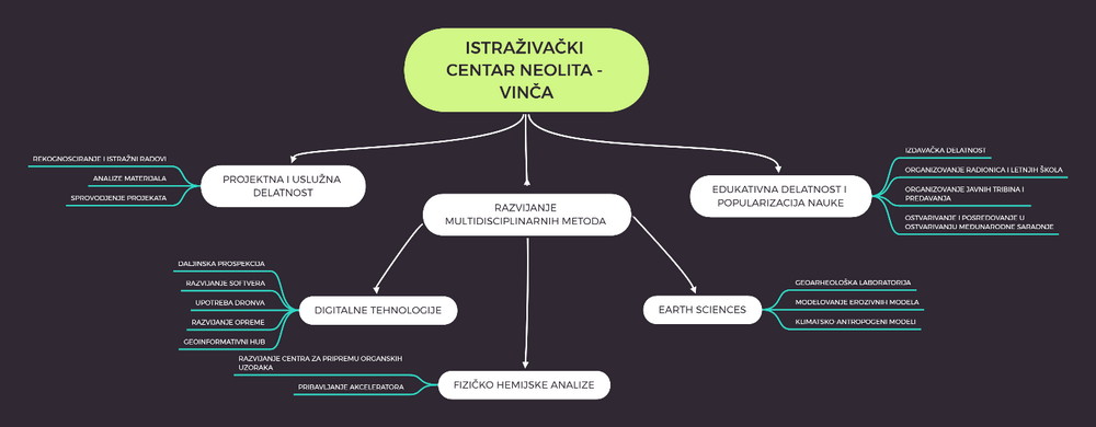
8.1. Competition subject, general guidelines and recommendations
The subject of the competition is the preliminary design of the scope for the Belo Brdo Archaeological Park complex in Vinča including the buildings for the Visitor Centre and the Neolithic Scientific and Research Centre, and it includes:
- Preliminary urban-planning and architectural design for the area covered by the Belo Brdo Archaeological Park complex,
- Preliminary design for the mobile elements and objects in the function of the Archaeological Site and the arrangement of the Protected surroundings of the Archaeological Site
- Preliminary architectural design for the Visitor Centre’s building with associated outdoor area
- Preliminary architectural design for the Neolithic Scientific Research Centre’s building with associated outdoor areas
- Preliminary design for the Archaeo Park area and the main parking of the complex with accompanying facilities
- Preliminary design for the development of the coastal zone of the Danube in the area of Belo Brdo Archaeological Park – promenade (arranged free and coastal areas activated with different contents), pier and revetment.
At the poll based design level, the subject of the competition includes also the preliminary designs for the arrangement of the left and the right banks of the Bolečica river adjacent to the zone covered by the competition, the area directly next to the traffic link between the Neolithic Scientific Research Centre subunit and the coastal of the Bolečica river, as well as the area of the Danube coast from the boundary of the zone covered by the competition upstream over the length of around 600m.
With respecting for the context of the location and its immediate surroundings, the exceptional importance of the archaeological site and the position of the area as a part of the coastal of the Danube – the longest and most important European waterway and an ecological corridor of international significance, all interventions need to be carefully considered with the aim to get to the best quality design solution possible, which is expected to enhance the functional and visual characteristics of the location and ensure the efficiency in the use of the space while preserving the uniqueness and value of the site. When conceiving the competition solution, it is certainly necessary to take into consideration the position of the Belo Brdo Archaeological Park complex in the context of the broader visible surroundings and the future development of the city of Belgrade.
The competition solution ought to exhibit a high conception level in the treatment of the cultural heritage protection which affirms contemporary tendencies in architecture. It is of exceptional importance to take into account, as an essential criterion, all aspects of the value and the irreversibility of the archaeological heritage, as well as the fact that this competition constitutes a part of the process of integrative protection of Belo Brdo archaeological site in Vinča through the promotion of its potentials as the generators of the scientific, cultural and tourist activities development.
An important element of the subject location are its potentials related to the visibility of the river and the connections with it, as well as the line of sight towards the river and the direct surroundings.
The competition solution ought to promote contemporary tendencies in architecture, as regards the shaping and developing of public spaces, including also a clear affirmative relation with all the sustainability aspects of the planned construction and development, both in connection with the realisation and in connection with the exploitation of all segments of the Complex.
8.1.1. Obligations as regards the forming of the space
- Recognisable architectural and urban-planning solution in conformity with the needs of the purpose, characteristics and importance of the site, which establishes a suitable bond with the surroundings;
- Urban-planning and architectural solution for the complex should be conceived in such a way that it is appropriate for the site within the scope of the ambience whole, both in terms of the physical structure and visual characteristics, and in terms of the programme, meaning the disposition of different contents;
- Character of the complex in the spirit and with characteristics of contemporary architecture;
- Primary requirements of the space organisation are the possibility of diverse flexible use, good spatial structuredness and easy orientation, simplicity and efficiency of the concept of communications;
- Movement of the users and visitors of the space should be logical, in line with the dynamics and the way of using different contents and the number of visitors.
- As regards the traffic, the incoming and outgoing roads ought to be organised clearly and simply;
- Ensuring good traffic accessibility without stationing dormant motor traffic outside the zone envisaged by the programme;
- Good functional connectivity within the subunit and between subunits, both in the horizontal and the vertical plans;
- Affirmation of the existing natural values and the ambience of the landscape, and the preservation of the autochthonous characteristics of the coastal zone;
- Protection of the archaeological site zones and the conditions for further archaeological surveying;
- Conditions and measures for the protection of cultural properties are binding;
- Vertical regulation of all permanent structures foreseen in the complex should be planned in line with the requirements related to the flood defence – the elevation of the ground floor’s floor should be at 76.50 m a.s.l. or higher;
- Use of the materials that have adequate environmental characteristics, in conformity with the programme and use-related needs and regulations in terms of safety;
- The designed solution need to provide for infrastructural equipment at the highest level, in terms of the comfort of the visitors and users of the space;
- All access routes, the areas intended for pedestrian movement and manoeuvre areas ought to ensure unhindered movement of the persons with difficulties in moving and persons with disabilities.
8.2. Programme elements and guidelines for the Belo Brdo Archaeological Park Complex
The area of the Belo Brdo Archaeological Park complex, which consists of several subunits, should be conceived in such a way that, both functionally and in terms of design, it forms a unique ensemble with recognisable visual identity.
The target groups of the users of the Belo Brdo Archaeological Park in Vinča are experts – archaeologists and experts from other professions in the context of the multidisciplinary character of the subject research, visitors – tourists (individual/group visits), students, pupils, employees of the Archaeological Park and the locals population.
The capacity of the Complex is planned for up to 1100 simultaneous visitors, taking into account all subunits.
The key manner in which the Belo Brdo Archaeological Park complex is to be used, with the aim to ensure its sustainability, is promoted through several aspects, including also the decreasing of the motor vehicle traffic within the Complex to a minimum and ensuring the so-called “soft” mobility within the tourist area. The users need to be provided with conditions for “cruising” the space with the help of rented segways, bicycles (ordinary and tandem) and scooters – Rent-a-bike; Rent-a-segway; Rent-a-scooter. Along the bicycle paths, there should be parking stations for parking and the pick-up / drop-off of these types of vehicles (for instance, in the thematic areas of the Archaeo Park, certain contents of the Danube coastal, etc., or in the places where one can expect a “stop” due to other attractive contents). It is also necessary to provide conditions for the movement of dedicated electric vehicles, primarily for the elderly and less mobile individuals, in such a way that that there is a link between the parking lot and all the subunits of the complex, while a similar purpose can served by a small train for which a daily ticket may be bought that allows the entry and exit at different stations depending on the interest.
In the context of promoting sustainability, greening of roof surfaces of the new structures, their activation for the purpose of energy and other potentials, in accordance with the function of the facility and the needs of the users of the purposeful contents, also give their share of contribution.
It has been envisaged that the access to the Archaeological Site and the Visitor Centre, as well as to different other facilities will be allowed only to visitors with tickets. In this context, it is necessary to provide for the possibility of fencing the Complex (except for the subunit Neolithic Scientific Research Centre), bearing in mind the specificity of the functional needs and the diversity of the user groups for each of the subunits.
The communication system in the Archaeological Park Complex should provide good connection of all subunits with the parking zone and between them, as well as comfortable movement for all categories of users.
It is necessary to provide conditions (in terms of communications) so that the guiding of organised visits has a continuous flow (circular guiding), starting from the Visitor Centre.
The subject of the competition task is also the design of the furniture within the ground floor arrangement of green and free areas of the Complex, which must obligatorily contain elements for respite (sitting, lying down, communication), elements for parking bicycles / segways / scooters with chargers (with an option to provide energy via solar station), lighting, waste baskets, as well as other elements depending on the specific needs of the subunit. The lighting is required primarily for public safety, movement control and the lighting of signs and instructions, but it should be kept in mind that lighting is an important element in the context of expanding the usability of the destination in the evening, an important factor in creating social atmosphere, while it may also be a valuable resource in the promotion of the ambience.
Elements of furniture, cladding and equipment of the ground floor, provided from adequate, resistant, durable and sustainable materials, in accordance with the concept of the proposed design.
8.2.1. Programme elements and guidelines for the subunit of the Archaeological Site
The Archaeological Site as one of the subunits of this competition includes the area of the archaeological site – 1st degree of protection (according to the Decision on the establishing of Belo Brdo in Vinča site as an archaeological site, “The Official Gazette of the RS,” no. 71/2009) and most of area belonging to the protected surroundings of the archaeological site – 2nd degree of protection.
The graphic presentation of the coverage of the Archaeological Site subunit is provided in the tender documentation – I INFORMATION GRAPHIC APPENDICES, appendix BOUNDARY OF THE COMPETITION AREA WITH THE PRESENTATION OF THE SUBUNITS.
The archaeological site (1st degree of protection) is an area within which active explorations are currently being carried out. The explorations are not carried out continuously on the entire surface of the site that enjoys the first degree of protection, but rather partially, covering different segments of this area, in line with the advancement of the expropriation process and the planned activities. The protected surroundings of the archaeological site (2nd degree of protection) is not a zone of active explorations at the moment, but it has the potential to become one in the future.
The target groups of the Archaeological Site subunit users are primarily experts – archaeologists and experts from other professions in the context of the multidisciplinary character of the subject research, visitors – tourists (individual/group visits) under controlled conditions and employees of the Archaeological Park, which does not preclude occasional participation of other groups of users of this space, also under controlled conditions.
ARCHAEOLOGICAL SITE (1ST DEGREE OF PROTECTION) includes the area bordered by the eastern regulation of Belo Brdo and Profesora Vasića streets, the southern borders of c.p. no. 2728, 2017/3, 2017/4 of CM Vinča, the regulation line that separates the archaeological site and the revetment, and the northern regulation of the planned extension of Nikole Pašića Street.
The primary access to the Archaeological Site (1st degree of protection) for visitors should be provided from the direction of the Visitor Centre subunit, with adequate connection between the Archaeological Site and the coastal and it is necessary to provide a checkpoint in the access zone. The primary approach for researchers is variable and it depends on the specific exploration area.
For the area of the Archaeological Site (1st degree of protection), the competition solution should provide for the presentation of the course of the archaeological exploration in situ, under controlled conditions, as well as further archaeological explorations and the protection of archaeological zones. The new structures at the site should be planned as temporary, prefabricated/dismantle and mobile, aboveground, structures and elements for different needs: the needs related to the work and gathering of researchers (A), the needs related to the access and movement of visitors (B) and needs related to the protection and presentation of the archaeological remains (C).
- STRUCTURES AND ELEMENTS FOR THE NEEDS RELATED TO THE WORK AND GATHERING OF RESEARCHERS
For the needs of the work and gathering of researchers, it is necessary to provide for the structures and elements (canopies, shelters, platforms…) which are mobile, flexible and multiplicative with the possibility of modification according to the needs of different positions, weather conditions and capacities, during the intended use.
The elements intended for the work and gathering of researchers include two categories, the first of which is positioned outside the area of the current exploration, while the second one is located in the area that is being explored (an archaeological probe).
The first category of the elements (the positions outside the exploration area) includes:
- area used for respite/break, which entails protection against sun in the summer and protection against the wind and cold during colder months.
- area used for office work and ad hoc meetings on the exploration strategies and dynamics, etc.,
- breakfast area,
- kitchenette and toilet facilities for the archaeological crew,
- area for the storage of tools (smaller and bigger tools – wheelbarrows, buckets, shovels, spades, etc.) and expendable supplies (bags, boxes, big bags, etc.) during the excavations
- area for the temporary storage of the excavated materials (until they are transported).
The second category of the elements that is positioned in the area being explored (the archaeological probe) entails different structures – paths, platforms, fences, canopies, shelters, etc., that need to provide more adequate and safer movement across the dig and the protection against the sun and storms, both for the archaeological crew and for the archaeological layers during the unveiling and excavations.
When designing these areas, it is necessary to take into account that the archaeological site zone also includes an area for the disposal of earth during the excavation from which the earth is going to be transported away.
The dimensioning of the elements intended for the work and gathering of researchers should be done on the basis of a 5-researcher group and in the manner that will allow by multiplication to meet the needs of larger researcher groups. The multiplication of the elements should be planned in such a way that it can satisfy different geometric and morphological conditions.
- ELEMENTS FOR THE NEEDS RELATED TO THE ACCESS AND MOVEMENT OF VISITORS
The elements for the access and movement of visitors (pedestrian paths, platforms) and for shorter presentations earmarked for visitors should be foreseen in the form of pre-fabricated/easy to dismantle platforms, ramps, etc., and systemic solutions for the temporary landscape arrangement without tall greenery and plant species that may endanger the protection of the archaeological site.
The prefabricated/dismantle pedestrian paths and platforms earmarked for visitors should be designed in such a way as to enable access, comfortable and safe movement near the site itself, without endangering the site and the works. The architectural solution should enable visitors to see the terrain next to and/or below the path and allow those who want to gain a more detailed insight (or follow the course of archaeological research for a longer period of time) to stall without disturbing passers-by. It is necessary that the paths are “elevated” in relation to the site in order to enable tourists to have the experience themselves of discovering an exceptional hidden cultural and historical heritage, while not disturbing the work of researchers with their presence.
Taking into account the impact of climate on the organisation of tourist activities (occurrence of windy days, rainy days and tropical days during the summer period), it is necessary to envisage smaller shelters for visitors within the pedestrian areas at the site.
The elements intended for short outdoor presentations ought to be dimensioned on the basis of 8 visitor groups, with the possibility of multiplication. The estimated maximum number of concurrent visitors to the archaeological site is 50, with a note that visits to the site involve smaller groups (each one with its own guide) that move along the defined paths (in a circular guidance model) according to the visit plan, so in this regard it is not necessary to provide conditions for the stay of all concurrent visitors at the same time in the same place.
It is desirable to consider the possibility of clearly setting apart two or more places within the archaeological site for the stalling of visitors (stationary observation points) in order for them to get acquainted with special/singled-out values of the site (e.g., watching the archaeological layers from the revetment or watching a group of houses (streets), watching selected archaeological artefacts, etc.).
- ELEMENTS FOR THE NEEDS OF ARCHAEOLOGICAL REMAINS PROTECTION AND PRESENTATION
It is necessary that the archaeological remains in the area of the site are protected against atmospheric conditions (rain, snow, frost, strong wind, excessive insolation, etc.). The solutions for this type of protection ought to be designed as temporary, prefabricated/dismantle and mobile elements (canopies, shelters) bearing in mind that owing to different weather conditions there is a possibility that condensation may be created in the enclosed space.
The presentation of the archaeological material should be such that there is no possibility of direct contact by visitors, except in the case of activities for which it is possible to foresee occasional participation of the public under controlled conditions (e.g., washing of the finds, sifting the soil, etc.).
When designing the solutions for the new structures at the site – the temporary, pre-fabricated/easy to dismantle and mobile structures and elements used for the explorations at the archaeological site, the needs of visitors and the auxiliary facilities, in addition to the mobility and flexibility, it is also necessary to provide for the possibility of phased implementation, taking into account the dynamics of the expropriation process that has so far been carried out on cadastral parcels no.: 2023/2, 2023/3, 2025/2, 2026/4, 2026/5, 2026/6, 2027/2, 2027/4, 2048/2 and 2047/2 of CM Vinča.
Since this concerns “construction” on an archaeological site, it is not allowed to form any underground spaces.
The existing structures at the archaeological site, which are currently used for organised gathering and work of researchers, as well as the structure presently used as an exhibition area, are planned to be removed.
The profile of Belo Brdo site has been created partly by the Danube water erosion and partly by the archaeological excavations and according to the currently valid legal and planning regulations, it constitutes an exhibit intended for the presentation. The demolition and constant building of new settlements formed the layers that successively raised the level of the ground, which is why this exhibit provides an opportunity to see the multi-millennial continuity of life in a single place, through almost 10m high cultural layer, the most valuable horizon of which is Vinča Culture that developed here for nearly 1000 years.
In this context, it is preferably to consider separately also a possibility of presenting this exhibit by providing for the vertical viewing along the profile, if allowed by the planned solution for the landslide rehabilitation (the rehabilitation project is enclosed with the tender documentation VI OTHER COMPETITION DOCUMENTATION).
THE PROTECTED SURROUNDINGS OF THE ARCHAEOLOGICAL SITE (2ND DEGREE OF PROTECTION), which belong to the Archaeological Site subunit, are currently not a zone of active explorations, but have an affirmed potential to become so sometime in the future. In this context, it is necessary in this section to plan primarily landscaped green and pedestrian areas accessible to all target groups of users, without using tall greenery and such plant species that threaten the protection of the archaeological site and in a way that entails the formation of pedestrian areas and segments by rising above the existing terrain (filling, platforms), bearing in mind the fact that valuable archaeological remains may be found already at a depth of 30 cm.
Within the Protected Surroundings of the archaeological site (2nd degree of protection), it is also necessary to envisage the prefabricated/dismantle Triage Centre facility northwest of the archaeological site (1st degree of protection), in one of the segments of the area mentioned below.
TRIAGE CENTRE
The Triage Centre facility should be planned in one of the following two locations:
(1) the area bordered by the northern and western regulations of Vinčanska Street, north of the intersection of Vinčanska and Palih boraca streets that form cadastral parcels 1994/1, 1994/2, 1995/1, 1995/3, 1995/4, 1996/1, 1999 / 1, 1999/2 and 2000, or
(2) the area bordered by the southern regulation of Palih boraca Street and the northern regulation of Vinčanska Street, southwest of the intersection of these streets that form cadastral parcels 2011/1, 2011/2, 2011/3 and 2012.
The Triage Centre facility that incorporates the following segments: triage area, field depot, material handling area, photo lab, conservation laboratory, workshop and auxiliary areas (toilet, kitchenette) should be designed as a prefabricated/dismantle, flexible, modular system structure, which, in terms of dimensions, can be adapted to the needs of the excavation capacities.
The organisation of the works at the triage centre implies the need for two entrances – an entrance for researchers and other participants in the work process and a cargo entrance earmarked for the delivery / dispatch of archaeological material that must provide for an easy and controlled access to transportation vehicle and equipment, taking into account both the possibly large weight of the material to be delivered and its possible fragility, as well as different weather conditions in which the unloading / loading may take place. The road access to the triage centre should be located outside the intersection zone of Vinčanska and Palih boraca streets.
Triage area 200m2
The triage area is intended for the cleaning, washing and sorting of the excavated material and it needs to be well connected with the field depot to which the packaged material will be moved after the triage.
The furnishing of the triage centre area includes: tables for the triage and packaging, shelves and frames for storing sieves for the drying of materials, furniture for the storing of equipment (bins, buckets, brushes, etc.) and connections for high capacity water supply and drainage. The structure for the storing of frames with the material to be dried (shelves on which the frames are placed) has the dimensions of 1x1 m and it is necessary for this element to provide the possibility of having direct warm air supply (e.g., heaters). Within the triage centre, there should be a smaller office space with an office desk for the needs of documentary work (computer, records, marking, archiving…).
Within the triage space, it is necessary to provide a storage room for expendable supplies, which include plastic boxes with the volume of 30 litres, T-shirt plastic bags of different sizes, freezer bags of different sizes, etc.
Field depot 100m2
The field depot is a facility (one or more rooms) intended for the temporary storage of archaeological material after the washing and drying. In most cases, the archaeological material is packed in plastic boxes of 30 litres (dimensions of e.g., 52x36x23 cm). It is necessary to provide space in the depot for shelves for the storing of the said boxes (minimum 120 boxes per year), then for the storing of whole/reconstructed vessels (dimensions of up to 1 meter high) and parts of immovable finds before/after conservation, as well as for separate finds of smaller dimensions that require special packaging. Within the depot, it is necessary to plan work surfaces (several tables) for opening and inspecting the boxes. It is necessary that the depot area is well ventilated and microclimatic, in terms of humidity and temperature, and controllable (constant temperature, no humidity).
Material handling area 50 -100 m2
The material handling area includes space for the installation of large work surfaces – tables, with the total surface area of at least 10m2, for the handling of archaeological material and space for documentation-related tasks, one workplace (records, marking, archiving…) – one office desk with computer.
- Triage area, Field Depot and Material handling area entail almost daily receipt and circulation of archaeological material and in this regard it is necessary to provide for direct and adequate connections among these areas.
Photo lab 10 m2
The area is earmarked for taking photos and scanning objects for the needs of documentation and creation of digital models. In terms of the content, the photo lab includes: a photo studio with equipment, a tent, a movable desk and working area for the photo and computer equipment (laptop).
Material conservation laboratory 50 -100 m2
The area for the conservation of movable and immovable archaeological material includes: large, well-lit work surfaces (with the possibility of additional specialised lighting), a cabinet for chemicals and expendable supplies (glues, cotton wool, gauze, clips, scalpels, plaster, paints, etc.). It is necessary that this laboratory has the possibility of adequate ventilation and the temperature and humidity control.
Workshop 20 m2
The area for the storing of tools and for minor repairs, sharpening of tools.
Accompanying areas
The accompanying areas include toilets and a kitchenette that need to be dimensioned for the needs of 10 concurrent users.
All the existing structures within the area earmarked for the realisation of the Triage Centre are without architectural values and can be planned for removal.
8.2.2. Programme elements and guidelines for the subunit of the Visitor Centre
The segment of the competition area intended for the Visitor Centre subunit with the total area of 23 260 m2, is located south of the archaeological site (1st degree of protection), from Nikola Pasic Street to the zone intended for the Archaeo Park, between the regulation of the archaeological site (1st degree of protection) in the east and the planned utility path in the west.
The Visitor Centre’s building is planned in the southeast section of the subject area, in zone of the 3rd degree of protection of the archaeological site within cadastral parcels no. 2028/14, 2028/15, 2028/47, 2028/48, 2028/77 and 2028/120 of CM Vinča, while the rest of the subject area belonging to the Protected Surroundings of the archaeological site (2nd degree of protection) is foreseen for ground floor arrangement green and pedestrian areas with contents in the function of the Centre.
The graphic presentation of the coverage of the Visitor Centre subunit is provided in the tender documentation - I INFORMATION GRAPHIC APPENDICES, appendix BOUNDARY OF THE COMPETITION AREA WITH THE PRESENTATION OF THE SUBUNITS.
The planned premises of the Visitor Centre should provide conditions for receiving and servicing all categories of visitors of the archaeological site (individually and in groups) and the presentation of the cultural heritage of the archaeological site in the context of its promotion as a tourist resource.
The target groups of the users of the Visitor Centre subunit are primarily visitors – tourists (individual/group visits), students and pupils, employees of the Centre and other employees at the Archaeological Park Complex, which does not exclude occasional participation of other user groups as well (training courses, workshops, playrooms, etc.).
The Visitor Centre building includes areas intended for visitors and areas for work intended for employees at the centre. The areas for visitors are intended to accommodate up to 120 concurrent visitors (all categories of users, individual and group visits), providing the necessary professional and service information during the visit to Belo Brdo Archaeological Park, presentations of the archaeological site through various forms of exhibits (artefacts, multimedia presentations, lectures, discussions…), a souvenir shop – bookstore, catering facilities (café), as well as auxiliary segments required by all visitors (respite, toilets, lockers…). The areas for work include premises for guides, work of the administration and management of the Centre, premises for the security and CCTV service at the Archaeological Park Complex (including also the storage space for the surveillance equipment) and the necessary supporting and technical segments.
It is necessary to envisage independent entrances into the building for visitors and employees.
The outdoor space in the function of the Visitor's Center, in addition to the ground-floor free and pedestrian areas, also include contents for visitors outdoor breaks, exhibits and presentations, a garden of catering facilities of the Center and the like. Within the outdoor area supporting the operation of the Visitor Centre, it is necessary to envisage adequately equipped parking for visitors’ bicycles / segways / scooters. When designing the organisation of the outdoor space in the function of the Visitor Centre, it is necessary to bear in mind the position of the separator / purifier – “the sewerage facility” within the scope of the local sewerage system planned in order to protect the archaeological site.
The graphic presentation of the planned route of the sewerage facilities and the position of the purifier is provided in the tender documentation - I INFORMATION GRAPHIC APPENDICES, appendix RESTICTIONS ON THE COMPETITION AREA.
All existing facilities within the Visitor Centre subunit are without architectural values and can be planned for removal.
BUILDING
Visitor areas (accessible to visitors and employees)
Entrance hall with info-centre and accompanying facilities (ticket selling, lockers…) up to 100m2
Multipurpose exhibit area 200 m2
Immersive experience room (multi-media presentation) 150 m2
Area for meetings/lectures with the capacity of 100 seats 150 m2
Community area for work and rest 100 m2
Bookstore and souvenir shop (gift shop) 50 - 100m2
Café 100m2
Accompanying facilities (toilets, communications…) up to 200 m2
The access and the main entrance for visitors should be planned in such a way that it is equally accessible to visitors coming from the direction of the coastal and visitors coming from the direction of the parking, i.e., the walking and bicycle paths. In the immediate vicinity of the entrance for visitors, there should be space for the elements used for the parking of bicycles / segways / scooters.
The multipurpose exhibition area should, in addition to providing conditions for various exhibition concepts, enable thematic education through various educational models.
The gift shop should be positioned in such a way that, in addition to the access from the interior of the Centre, it also has an independent external access. The café should be dimensioned so that it has 40 seats inside and 60 seats in the garden.
All of the accompanying facilities earmarked for visitors (toilets, lockers, communications…) should be dimensioned on the basis of 120 concurrent visitors.
Work areas (accessible only to employees)
Office space for 4 curators 45-60 m2
Offices for the management and administration (accounting, legal service) 60-80 m2
Premises for the Archaeological Park Complex surveillance and security service 45-60 m2
Accompanying facilities (kitchenette, toilets, communications…)
The office space should be designed as flexible with the possibility of different organisation models (classic offices or the “open-space” area) in line with the needs of each of the contents, with a note that the organisation of the space earmarked for management and administration should be foreseen as 3-4 classic offices.
The area intended for the Archaeological Park Complex surveillance service entails organisation in a manner suitable for the storage of equipment for electronic and video surveillance and the work with it.
All of the accompanying facilities earmarked for employees (toilets, kitchenette, communications…) should be dimensioned on the basis of up to 20 employees.
Total the Visitor Centre building (net surface area) up to 1400 m2
The planned position of the Visitor Centre building has the potential of good quality views of sight at the archaeological site and the Danube from the roof surfaces of the building. In this context, it is desirable to consider the activation of roof surfaces as a green roof of the roof garden type (semi-intensive / intensive green roof) as additional contents of the outdoor area of the Centre – the greenery (primary element), the viewpoint, the respite area, etc., intended for visitors and employees.
The elevation of the ground floor of the building, in conformity with the flood protection conditions, is at 76.50 m above sea level.
OUTDOOR AREAS
The outdoor areas in the function the Visitor Centre should be designed to provide conditions and facilities for respite and stay of visitors (and employees) outdoors, for displaying of exhibits and presentations, as well as for the needs of the catering facility’s garden, children playground, etc., including also adequate ground floor arrangement of free, pedestrian and green areas. All the segments of the outdoor areas of the Centre need to be dimensioned in line with the planned number of concurrent visitors.
The ground floor arrangement and landscaping should be planned in such a way that it is accessible to all categories of users, without any inclusion of tall greenery and plant species that may endanger the protection of the archaeological site and in a way that involves the formation of pedestrian areas and segments by raising them above the existing terrain (filling, platforms), keeping in mind the fact that most of the subject area belongs to the 2nd degree of protection of the archaeological site, that valuable archaeological remains may be found already at the depth of 30 cm and that in the future the subject area may become a zone of active archaeological explorations.
When designing the solution for the ground floor arrangement, it is important to keep in mind the flood protection conditions – that the regulation line for high waters, i.e., the flood defence line is at the elevation of 76.50 m above sea level.
8.2.3. Programme elements and guidelines for the subunit of the Neolithic Scientific Research Centre
The area of the Neolithic Scientific Research Centre subunit includes cadastral parcels no. 2070/1 and 2070/4 of CM Vinča. The building on cp 2070/4 is foreseen to be removed, while within cp 2070/1 there is an old school building that is no longer functional, that is without architectural values and is also planned to be removed, but it is still possible that the competition solution provides for its reconstruction, i.e., the incorporation of the existing physical structure into the newly formed structure of the Neolithic Scientific and Research Centre.
The graphic presentation of the Neolithic Scientific Research Centre subunit is provided in the tender documentation – I INFORMATION GRAPHIC APPENDICES, appendix BOUNDARY OF THE COMPETITION AREA WITH THE PRESENTATION OF THE SUBUNITS
The goal of establishing the Neolithic Scientific Research Centre is to improve the research of Neolithic cultures in the Republic of Serbia and the region through multidisciplinary approach and methods, educational activities and popularisation of science. One of the primary motives for the setting up of the centre is the education and training of young researchers in the state of the art technological conditions, through project work and gaining of experience through practical work, multidisciplinary approach along with circular interchange of staff.
The document specifying the goals linked to the founding and competences of the Neolithic Scientific and Research Centre - Vinča Belo Brdo is enclosed with the tender documentation VI OTHER COMPETITION DOCUMENTATION.
The area of the Neolithic Scientific Research Centre consists of two functional units – the research part of the centre (A) intended for the work of researchers and the presentation of the research, and the accommodation part of the centre (B) intended for stationary stay of researchers.
The functional units of the Scientific Centre need to be designed in the way that ensures good connectivity among the units, as well as among different segments within each one of them. The entrances to the building (the number, position and purpose) should be designed in line with the needs of the activities of each one of the functional units. The vertical communications within the Research Centre should be envisaged in the way that enables comfortable movement for all categories of the area users (lifts), as well as in a way that ensures the meeting of the needs related to the transport of all types of samples and materials, given their possible large weight (freight lift).
The initial estimated number of employees at the Research Centre is 25 employees – laboratory assistants, operatives, IT experts, economists, a lawyer and the centre’s management.
The target groups of the users of the Neolithic Scientific Research Centre subunit are primarily experts – archaeologists and experts from other professions, administrative workers and associates of the Scientific Research Centre, as well as guests of the centre and participants in meetings/events, which does not exclude occasional participation of other groups of users (e.g., visitors of the activities intended for broader public that may be organised at the centre), under controlled conditions.
The architectural solution for the Neolithic Scientific Research Centre should be designed, both in terms of functionality and in terms of form, in the way that will in the future allow addition (construction / extension) of new premises, while providing adequate connections with the original segments of the centre.
- RESEARCH PART OF THE CENTRE
In functional terms, the research part of the centre includes two interrelated segments: the segment intended for work areas (A1) – laboratories and other types of work areas and the segment for presentations and meetings/events (A2) intended for research presentations and various types of scientific and professional events.
Regarding the segments of the research part of the centre, it is necessary to provide three independent entrances: an entrance for employees (provides access to the work areas, with entrance control), a cargo entrance with covered unloading / loading areas (provides for the needs related to the delivery/shipping of samples for the work area zone intended for laboratories) and an entrance for visitors (provides direct access to the spaces intended for presentations and meetings/events).
Within the research part of the centre or using a covered communication connected with it, it is necessary also to foresee a Garage for off-road vehicles. The garage needs to be dimensioned for the capacity of 5 vehicles, while within the garage it is necessary to provide conditions for their daily hygienic maintenance.
(A1) WORK AREAS
The segment of the research part of the centre intended for the work areas entails a controlled access available for employees and visiting researchers, as well as for the guests of the centre under controlled conditions.
The work area zone should be well connected with the entrance for employees, with the cargo entrance (laboratory), as well as with the segment of the spaces intended for research presentations and meetings/events.
LABORATORIES
Geophysical centre 100m2
The geophysical centre consists of a safe room for the storing of equipment and an area for maintenance and development.
The equipment storage room is intended for the storage of valuable geophysical equipment – fluxgate magnetometer with accompanying field equipment, total stations, GPSS, a drone. The access to the equipment storage room is in the category of strictly controlled access, which is provided only to persons with access permission.
The maintenance and development area is intended for occasional maintenance of the equipment, including also the checking of the equipment that requires more space for handling. Within this area, it is necessary to provide for the positioning of a total of five jobs posts: two jobs for the workshop operations – 2 desks measuring 2x1m and a tool shelf, and three jobs for the work on computers, each one with one computer. The minimum clear height of the area is 2.60 meters.
Laboratory for the preparation of organic samples 100m2
The area of the laboratory for the preparation of organic samples should be positioned in such a way as to provide conditions for strictly controlled access and a high level of security. As the work in this laboratory also implies work with highly flammable gases, it is necessary to provide conditions for adequate ventilation, good control of contamination and implementation of the necessary fire-fighting measures, both in terms of staying and working in the area, and in case of an evacuation. The minimum required clear height of the area is 2.60 meters.
Geo-archaeological laboratory 50m2
The geo-archaeological laboratory should be positioned within the ground floor area, or maybe on the first floor of the building, bearing in mind the need to deliver and ship samples that are often very heavy and require manual handling.
The geo-archaeological laboratory includes a “wet room” and a room with microscopes.
The “wet room” is intended for analysing soil samples – granulometry using the pipette method, determining of the pH, furnace for the analyses of the loss by annealing and determining of organic carbon content, etc., with the necessary laminars, fume cupboard, work surfaces, shelves and elements for storing spare parts and expendable supplies, sediment cutting and sample preparation machine, pXRF apparatus. The laminars and fume cupboards with fume hood – 2 pieces (each 120cm long with special ventilation), work surface areas – 4 tables each 2 meters long, on which the analysis apparatuses are placed and the area for granulometric analyses – 3 m2 in which a sieve, pipettes, sample table and high-precision scales are placed. It is also necessary to have at the “wet room” connections for water supply and drainage, space and a machine for washing laboratory vessels, cabinets for chemicals, dryer, shelves for storing preparations and samples, etc.
The room for storing microscopes, i.e., for working with microscopes and analysing preparations, is an area with work surfaces (tables) used in order to place two microscopes – a metallographic/petrographic microscope with accompanying equipment (a computer and a digital camera) and a light/optical microscope. The dimensions of the microscopes – height 150 cm and width 80 cm.
The minimum required clear height of the geological laboratory area is 2.60 meters.
When organising the laboratory area, it should be taken into account that the equipment for laboratories will be procured successively, as well as that there is a possibility of changing the equipment (in line with the advancement of technology) and the expansion of activities.
Biological (bio-archaeological) laboratory 100m2
The biological laboratory should be positioned in such a way that in addition to the main access from the interior of the centre, it also has a direct connection with the outside area (yard) and a possibility of an independent water supply and drainage connection for flotation needs. This laboratory space should provide for the possibility of working on three microscopes and four investigative tables and space for storing biological material.
The investigative tables are 200 x 100 cm (with scale dividers on the side). For the needs of archeozoological analysis, it is necessary to have space for a comparative collection – shelves and drawers 2 meters high, 70 cm deep and 1.60 m long.
A special section within this laboratory is the office space where microscopes are located (dimensions of the microscopes – height 150 cm and width 80 cm), shelves with samples and expendable supplies.
The minimum required clear height of the bio-archaeological laboratory is 2.60 meters.
Pollen analysis laboratory 100m2
A separate room – a clean room (a room with controlled, filtered ventilation), for sample preparation. Ventilated laminar, a locker under key for keeping chemicals, laboratory tables. Storage space for keeping samples in cold conditions (box freezer or a cold room/freezer for storing plastic tubes 1 meter long).
Separate area for microscopes and samples. Light microscopes with 20x and 40x magnification, DIC, polarising light, digital camera, connected to an appropriate computer with software. Digital reference catalogues of pollen.
Computer laboratory + server room 150 + 30m2
The computer lab and the server room should be planned as two connected units. The area of the computer laboratory should be envisaged in such a way as to provide conditions for dividing the space into individual positions / boxes for a total of at least 10 job posts, three of which are intended for IT experts employed at the computer laboratory, while the rest are for visiting researchers and other employees at the centre. The server room should meet the requirements in accordance with the security needs related to the protection against high voltage shocks and fire protection.
OTHER WORK SPACES
Documentation + archives 30 m2
The area for storing publications, catalogues, books and periodicals and for storing archives that includes extensive field and project documentation covering the period of several decades of research at Belo Brdo site.
Storage/warehouse 20 m2
Storage space for expendable supplies, office supplies (paper, toner, expendable supplies), sanitary supplies (toilet papers, paper towels, soaps, cleaners, etc.) including a separate area for storing chemicals.
Office space for the management and administration 200 m2
The office space should be designed as flexible with the possibility of applying different organisation models (classic offices or an “open-space” plan), with a note that the organisation of the space intended for the management uses the model of 3 classic offices – manager’s office accessed independently and through the secretary’s office + space for smaller-scale meetings (6 seats). It is also necessary to provide conditions for the setting up of two independent offices with one job post each for guests participating in the work of the centre.
WORK AREAS – ACCOMPANYING FACILITIES
Toilets, kitchenette
The sanitary areas (toilets) and the kitchenette should be dimensioned for the total capacity of 25 daily employees + 20 visiting researchers.
(A2) AREAS FOR PRESENTATIONS AND MEETINGS/EVENTS
The segment of the Research Centre intended for presentations and meetings/events is available to all target groups of the users of the Research Centre space.
The zone intended for presentations and meetings/events needs to be provided with a direct access through the entrance for visitors (bearing also in mind situations for which it is necessary to provide access control) and an adequate connection with the work areas of the Research Centre and the accommodation part of the centre.
Multifunctional exhibition-conference area 500 m2
The exhibition-conference area includes the following
- a conference hall with the capacity of 150 seats, adequately equipped in terms of technology, flexible for various forms of presentations and communications, and easily dividable into three smaller halls with the capacity of 3 x 50 seats, and
- hall area (lobby) adjustable to the needs of different forms of exhibitions, cocktail parties, etc., which permits access to all the options of the conference room organisation; along with the hall area, it is necessary to envisage an auxiliary premise for the needs of preparing / serving beverages during cocktail parties, etc., which has a contact with the communication – link with the accommodation part of the centre.
2 conference offices 2x50 m2
The conference offices are intended for organising smaller-scale meetings with the capacity of 10 to 20 participants. They contain a conference table and chairs, and are organised and technologically equipped to meet the needs of modern presentation models (video beam, screen, whiteboard...). The conference offices should be easily accessible from the lobby.
AREAS FOR PRESENTATIONS AND MEETINGS/EVENTS – ACCOMPANYING FACILITIES
Control room – area for the surveillance service of the Scientific Centre and the security 30-45 m2
The area intended for the CCTV service for the Scientific Centre entails such organisation that it is appropriate for the arrangement of the equipment for electronic and video surveillance and the work with it.
Handy storage room up to 50 m2
The storage room is intended for the storing of equipment used for the multifunctional exhibition and conference area (tables, display boards...) in the context of diverse possibilities for their organisation and use.
Sanitary areas
The sanitary areas (toilets) should be dimensioned for the total capacity of 150 concurrent users.
Communications, brake out areas for (A1) and (A2) up to 15% of the gross surface area
The communications should be designed in a logical and rational way in accordance with the programme and in the spirit of the solution’s design. The windshields, stairways, possible platforms and lifts ought to enable efficient circulation and good organisation and connectivity between the functional units.
TOTAL – RESEARCH PART OF THE CENTRE up to 1850 m2
- ACCOMMODATION PART OF THE CENTRE
The accommodation part of the centre is intended for the stationary stay of researchers and it includes:
10 – 15 accommodation units (20 beds) each one with its own bathroom around 400 m2
Small kitchen for receiving food and a possibility to prepare food, with smaller capacities on the spot around 50 m2
The small kitchen for receiving food is intended for receiving and serving food brought by catering suppliers with the size in line with the capacity of the Multifunctional Exhibition and Conference Area (150 concurrent users), as well as the food-preparation needs in line with the capacity of the accommodation part of the centre (20 users).
Dining room around 50 m2
Parlour around 100 m2
Accompanying facilities and communications around 120 m2
TOTAL - ACCOMMODATION PART OF THE CENTRE up to 750 m2
8.2.4. Programme elements and guidelines for the Archaeo Park and the main parking of the complex
The zone intended for the Archaeo Park subunit includes the area in the background of the direct coastal zone of the left bank of the Bolečica, from the boundary of the Belo Brdo Archaeological Park SPSPA towards the north and it consists of the following cadastral parcels: 2028/5, 2028/6, 2028/23, 2028/24, 2028/30, 2028/32, 2028/69 and 2028/110 of CM Vinča and parts of cadastral parcels: 2028/18, 2028/19, 2028/20, 2028/21, 2028/22, 2028/25, 2028/33, 2028/34, 2028/35, 2028/37, 2028/70, 2028/84, 2028/85, 2028/86, 2028/109 and 2028/111, with the total surface area of 65 880m2.
The graphic presentation of the coverage of the Archaeo Park subunit is provided in the tender documentation – I INFORMATION GRAPHIC APPENDICES, appendix BOUNDARY OF THE COMPETITION AREA WITH THE PRESENTATION OF THE SUBUNITS.
In terms of the contents, the Archaeo Park includes four categories of the areas intended for visitors:
- areas earmarked for thematic features
- open spaces organised and equipped for multifunctional use – exhibits, workshops, multidisciplinary interactive events
- the outdoor work spaces, and
- areas for respite and relaxation
The first two categories are primary and green areas as the primary features in terms of the ambience.
The purpose of the areas with thematic features is to acquaint visitors with the everyday life and culture of the Neolithic Vinča, i.e., to provide such conditions that the visitors may have the experience of life in the Neolithic age. The thematic features include areas intended for the reconstruction of the conditions in which the daily activities of the Neolithic inhabitants of Vinča took place – food preparation, hunting, fishing, Neolithic crafts, activities related to grain growing and early metallurgy, models (whole or segments) of life-size Neolithic houses made by applying Neolithic construction techniques, then areas for alternative artistic features with themes and elements of the Neolithic Vinča’s everyday life, production, rituals, as well as presentations of artistic and functional objects, plus providing conditions for interactive outdoor social games.
The themes will include:
- housing and housing activities (e.g., Neolithic kitchen activities that can be demonstrated in one of the Neolithic house reconstructions equipped with a hearth, stoves and storage vessels, or reconstruction of outdoor stoves where the baking method from the Neolithic era can be demonstrated)
- houses (residential buildings) – appearance and technology
- Neolithic activities – agriculture (e.g., presentation of the manner in which grains were grown), livestock husbandry, hunting (e.g., Neolithic bow and arrow shooting range as a simulation of hunting in an adequately positioned and secured area measuring 30x20m), fishing, collecting wild fruits
- Neolithic flora – exposition of the Neolithic flora (e.g., “Agriculture Museum/Botanical Garden” – with species of plants and grains that were present during the Neolithic period in Vinča, etc.)
- Neolithic fauna – mammals, birds, fish, wild and domestic animals (e.g., Neolithic Petting Zoo – young domesticated animals from the Neolithic period move freely within an area organised for the purpose, including also reconstructed “Neolithic” canopies as shelters from the heat...)
- utility, decorative, ritual and artistic objects
- tools, weapons, implements, household vessels
- objects of religious and artistic character
It is desirable that the areas intended for thematic features are designed as flexible and multifunctional, in terms of the implementation of different topics and with the possibility of changing the topic.
The multifunctional open spaces ought to provide conditions for exhibitions, interaction, as well as for holding thematic workshops for visitors of different ages, which as some of the topics may include the following:
- pottery workshop using Neolithic techniques,
- various workshops on scientific and research work and archaeological methods – how archaeologists obtain data, how archaeological material is processed
- playrooms – assembling pottery vessels from fragments
- archaeology for children – e.g., a field work workshop: an area where there are no archaeological remains prepared for digging with participation of the youngest visitors entails that 5x5 m probes with discarded pieces of pottery and house daub are covered with earth only to be dug by children, as well as workshops for knapping, carpentry, textile, pottery and similar activities. Flotation, wet rinsing of the finds is also interesting for children)
The outdoor work spaces should be envisaged through several options – individual work and work in smaller groups with a possibility of providing canopies and with adequate infrastructural equipment (solar chargers, etc.).
MAIN PARKING OF THE COMPLEX
Within the Archaeological Park subunit, in the zone of direct traffic access from the public traffic area, it is necessary to envisage the main parking of the Archaeological Park Complex intended for all categories of users (employees, visitors), all categories of passenger vehicles and buses/coaches, as well as special purpose vehicles: ambulance, OB vans, fire trucks and security vehicles.
The parking area should be planned as an open, independent, surface parking lot, with the parking capacity for 250 passenger vehicles (at least 5% of which is intended for vehicles of people with disabilities and reduced mobility) and 10 buses/coaches. No special parking spots are envisaged for special purpose vehicles.
In the parking zone it is necessary to plan a facility to be used as an info - point that should have conditions for the sale of tickets, distribution of appropriate material that will provide visitors with the necessary information about the features of the tourist area belonging to the Archaeological Park complex, as well as for the rental and disposal of bicycles, segways and scooters. Sanitary facilities (toilets) for visitors are also planned within this structure.
In terms of the capacity, the vehicle access to the parking lot (entrances/exits) should be positioned and planned in such a way as to ensure an unhindered flow. It is necessary to provide for good connection between the parking zone and the walking and bicycle paths, as well as all other communications that provide access to the features of the Archaeological Park and the coastal zone. The organisation, arrangement and landscaping of the parking zone ought to be done in a way that diminishes the impression of a large empty space.
TECHNICAL BLOCK FOR THE NEEDS OF THE COMPLEX MAINTENANCE
Within the Archaeo Park subunit in the zone to which access is provided from the parking lot, it is necessary to envisage a Technical Block for the needs of maintaining the Archaeological Park Complex. The Technical Block will contains garage space intended for parking, maintaining and daily washing of vehicles and machinery, as well as space for the stay of the maintenance employees.
The capacities of the garage space should be dimensioned for the parking of 5 small tractors with mowing accessories, dozer blades and other necessary accessories, one snow machine, 10 trimmers for the maintaining of the greenery (cutting branches, edges, etc.), as well as for the storing of larger tools (compressor, chainsaws) and manual equipment and tools, and 5 dedicated electric vehicles with a capacity of 2 to 4 passenger seats.
Within the area for the stay of the employees, it is necessary to envisage changing rooms, a sanitary block (toilets and showers) and a respite area for 10 maintenance workers, office space for three employees and a kitchenette.
When designing the solution of the Archeo Park subunit, it is necessary to take into account that this subunit, in addition to being intended for the above contents, represents, in the context of the Belo Brdo Archaeological Site Complex, the space within which the primary connections of the Complex are realized- connecting the access zone (parking) with all the contents of the Complex, as well as connecting the access zones with each other (parking - pier). In this sense, it is necessary to provide conditions for comfortable movement for all planned movement options of users of the Complex - pedestrian paths and surfaces, bicycle path (bicycles / segways / scooters), as well as conditions for movement of dedicated electric vehicles and adequate equipment of these communications facilities (lighting, break elements, bicycle parking elements…).
When designing the architectural solution and the ground floor arrangement of the Archeo Park subunit, it is necessary to keep in mind the conditions linked to the flood protection – that the regulation line for high waters, i.e., the flood defence line is at the elevation of 76.50 m above sea level.
The areas of the Archaeological Park subunit should be designed in the way that they form a unique ambient unit of recognisable visual identity, while ensuring transformability.
8.2.5. Programme elements and guidelines for the subunit of the Danube coastal – revetment, promenade (arranged free and coastal areas activated with different contents) and pier
Within the scope of this competition, the Danube coastal subunit with the planned purpose of the revetment, promenade and passenger pier covers the area between the low water regulation line and the boundary of the archaeological site (1st degree of protection), from the confluence of the Bolečica in the south to the boundary of the area covered by the competition in the north.
The graphic presentation of the coverage of the Danube coastal subunit is provided in the tender documentation – I INFORMATION GRAPHIC APPENDICES, appendix BOUNDARY OF THE COMPETITION AREA WITH THE PRESENTATION OF THE SUBUNITS.
The most demanding intervention within this subunit, both in terms of technology and in terms of functional limitation for the other features in the coastal zone is certainly the planned construction / reconstruction of the protective hydro-technical revetment structure.
The construction of hydro-technical structures for the use of waters and protection against waters constitutes a priority in the zone of the Danube coastal, including also the direct coastal segment of the future Archaeological Park. The protective structure (embankment/quay), as a part of urban regulation should be treated in line with the concept of the solution for the development of the riverbank that ought to be adjusted to the needs of cultural heritage while providing conditions for its sporadic or permanent presentation within this subunit as well and with an obligation that the conditions for unhindered access to the water are provided along the entire riverbank. The crown elevation of 76.50 m a.s.l. has been adopted for the said protective structure.
The arrangement and use of the coastal, primarily as a public urban space that connects other public spaces with its linear form, constitutes its specificity. It is suggested to develop a network of several smaller public urban areas. Adequate landscaping of the coastal is one of the important factors in achieving direct contact between people and the ambience of the Archaeological Park that has a positive effect on the attractiveness and accessibility while improving the general conditions of pedestrian movement.
The REVETMENT should be planned in the zone covered by the competition (including the segment of the coastal foreseen for the poll based design level) in such a way as to ensure its continuity and the continuity of the defence line at prescribed levels of the protection from the relevant high waters along the entire stretch, as well as the communication aimed at facilitating the flood protection and regular maintenance. In the hydro-technical sense, the revetment should be based on the basic principles of construction of the revetment on the territory of the City of Belgrade and on the Danube.
When developing the solution for the regulation zone of the coastal, it is important to bear in mind the following regulation lines:
- basic regulation line (for low waters) that follows the line of the lower parts of the existing banks of the Danube and in terms of the height it defines the outer edge of the stone “foot” crown – the revetment with the elevation of 70.50 m above sea level;
- regulation line for high waters, i.e., the flood defence line, defines in terms of height the upper plateau of the revetment at the elevation of 76.50 m above sea level. Its position in space is not fixed. The basic hydro-technical requirement is to ensure the continuity of the defence line at the qualified level of flood protection, either by a permanent structure or by a combination of a permanent structure and mobile protection.
In addition to the basic function (protection against high waters, static and filtration stability), the hydro-technical solution for the development of the riverbank must also meet the following requirements:
- ensuring the continuity of the regulation and the defence lines with the downstream and the upstream sections in conformity with the relevant planning, i.e., hydro-technical solution;
- ensuring appropriate connection between the higher levels of the riverbank and the river;
- connection with the planned pier;
The existing revetment, built in the part of the riverbank within the area covered by the competition (in the Archaeological Site zone) with the length of 260 m, the crown elevation of which is at 74.00 m above sea level and is not in compliance with the flood protection conditions (76.50 m above sea level), should be incorporated into the planned solution.
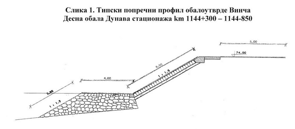
51. Graphic image of the type cross-section existing profile of Vinča revetment. Source: Documentation JVP SRBIJA VODE
The features of the coastal zone arrangement entail landscaped, free, green and recreational areas, pedestrian flows and a bicycle path, and they may also include providing conditions for the occasional specific activities related to, e.g., smaller capacity musical, theatrical, artistic and similar events, through adequate infrastructure and multifunctional / transformable landscaping elements.
When designing the solution for the coastal zone, it is necessary to keep in mind the activities on the riverbank and on the river itself, taking into account the climate conditions of the subject area that have a seasonal character, as well as that the Danube potentials can be a part of the diversification of the offer within the scope of various special forms of tourism.
In the coastal zone should be planned a smaller prefabricated object - info point which should provide conditions for ticket sales and distribution of appropriate material that will provide visitors with the necessary information about the tourist area of the Archaeological Park complex. That facility should also serve for the rental and disposal of bicycles, segways and scooters (with a smaller capacity), and should have also sanitary facilities (toilets) for visitors.
The area along the river should be designed in a way that ensures access and safety for all categories of users, the possibility of adequate lighting and maintenance, as well as protection of users that may be required in case of a sudden change weather.
It is necessary that the coastal area is adequately and comfortably connected with the main communications of the Archaeological Park complex – the walking and cycling paths, as well as with the Visitor Centre and the Archaeological Site subunits.
It is also necessary to plan for adequate urban furniture in the coastal area which must mandatorily contain elements for respite (sitting, lying down, communication), elements for parking bicycles / segways / scooters with chargers (with the option to provide energy through a solar station), lighting, trash cans, etc.
The contents of the coastal zone the dimensioning of which is impacted by the user capacity should be dimensioned on the basis of the capacity of 1/3 of the projected total number of concurrent users of the Belo Brdo Archaeological Park complex - 320 users.
Larger existing green areas should be kept and incorporated into the planned solution.
The PIER for smaller tourist boats and excursion boats, adapted for receiving and dispatching passengers in the internal traffic system, planned as a pontoon pier (using the existing pontoon from 2020, intended for smaller vessels) with reduced capacity of the necessary supporting facilities – covered access, meeting the requirements for the receiving of vessels and passengers, controls and safety of passengers, adequate connection with the riverbank), while providing for the possibility to include the stop in the network of the public transport of passengers by water.
The existing pontoon, positioned in the coastal zone in the zone of the Archaeological Site (1st degree of protection), is connected to the riverbank by an access bridge that provides access at the elevation of 74.00 m above sea level.
The pier area – the pontoon and the access riverbank must meet the following requirements in relation to pier infrastructure:
- hydro-engineering structures that make up the pier’s riverbank, as well as operational and working areas must be properly constructed and they also must be kept in a technically correct condition
- have a pontoon with an access bridge or appropriate crossings for safe movement of people on the vessel-riverbank route
- the pontoon must ensure the acceptance of the envisaged categories of passenger ships, provide conditions for their proper mooring, be adapted for safe connection with vessels with the help of a crossing bridge
- operational riverbank must be secured using a prescribed and functional fence in order to prevent possible falls of passengers into the water
- the surfaces of the pier must be flat, made in such a way as to have a non-slippery surface, without things, goods and vegetation that interfere with movement, with an efficient water drainage system
- direct access to the pontoon and the passenger ship must be fenced off, controlled and with physical or technical security
- access bridge must have the minimum width of 1.5 m in order to allow for the throughput capability for the movement of persons in case of emergency situations when leaving the facility quickly, as well as to be adapted, constructed and equipped to allow the movement of all categories of users including also persons with disability
- pier area must be properly marked, regulated by vertical, horizontal and light signals and well lit
- port area of the pier, including the pier’s water area, must be under constant supervision and control for the purpose of security protection
- access to ambulances, police and rescue and fire-fighting services must be provided and passable at all times
Detailed GUIDELINES OF THE PORT GOVERNANCE AGENCY are provided in the tender documentation – III GUIDELINES OF COMPETENT INSTITUTIONS
All of the existing facilities and structures in the coastal zone on the water (except for the pontoon used as a pier for smaller vessels), as well as on the riverbank have been installed without the prescribed permits and are intended to be removed.
The arrangement of the coastal area should be designed in a way that they form a unique ensemble of a recognisable visual identity.
The lines of sight from the promenade along the banks of the Danube towards the river and the Archaeological Park constitute one of the most important qualities of the wider location that need to be preserved and promoted. The lines of sight from the river towards the archaeological site also have an equal value and they provide for an opportunity to have a complete understanding of the identity of the site’s area.
8.2.6. Programme elements and guidelines for the arrangement of the left and right riverbanks of the Bolečica (as a poll based design)
The banks of the Bolečica within the poll based design part of the competition include the area within the regulation of the Bolečica from the confluence with the Danube upstream over the length of around 660.0 m.
Along the left and the right banks of the Bolečica, it is necessary to plan the setting up of a green corridor in order to establish an ecological network at the local level and thus preserve the biodiversity, protect the land from the harmful effects of erosion (water, aeolian) and improve the ambience values of the setting, in accordance with the solution of traffic and infrastructure envisaged by the PDR for the primary facilities of the Boleč Sewerage System - PHASE I.
When planning the arrangement of the banks of the Bolečica, it is necessary to keep in mind that what needs to be done is as follows:
- Preserve the good quality woody vegetation and incorporate it into the planned solution;
- The types of plantings can be individual trees, tree lines, woody-bushy groups, protective belts and continuous massifs;
- Ensure the stratification of the protective green belt by using herbaceous, bushy vegetation ...
- Selected species for the landscaping should correspond to habitat conditions,
- Use deciduous tree species with pronounced sapling strength and dense canopy, but also evergreen and coniferous species in order to achieve functionality in the winter as well,
- Avoid species that have been established as allergens (poplar, etc.), invasive species are prohibited (black locust (Robinia pseudoacacia), box elder (Acer negundo), tree of heaven (Ailanthus altissima), etc.);
The graphic presentation of the new regulation of the Bolečica – the position and the cross-section profile is provided in the tender documentation – IV INSERTS FROM PLANNING DOCUMENTS, appendix, the PDR (Detailed Regulation Plan) for primary facilities of Boleč sewerage system – PHASE I, Regulatory - levelling plan.
8.3. Special programme conditions, guidelines and recommendations for all subunits
8.3.1. Urban-planning and parametric requirements
The urban-planning and parametric requirements related to the planned construction capacities (occupancy, index, floor area ratio, number of floors), as well as the cultural heritage protection conditions, the conditions for green areas, and the engineering and geological conditions for different subunits are listed in conformity with the Spatial Plan for the Special Purpose Area of Belo Brdo Archaeological Site (“The Official Gazette,” no. 85/18). This call for tender also defines new goals and features of the Archaeological Park with the Visitor Centre and the Neolithic Scientific and Research Centre that will be the basis for the amendments and supplements to the subject spatial plan.
Urban-planning and parametric requirements for individual units
- Archaeological Site subunit
- Archaeological site (1st degree of protection)
|
Basic purpose of the areas |
Structures supporting the archaeological site. |
|
Construction of new buildings and the position of the buildings/structures on the land parcel |
It is possible to set up several temporary (pre-fabricated/dismantle) buildings/structures supporting the explorations and presentations of the archaeological site – for the needs of the work and the gathering of researchers, visitor access and movement, and protection and presentation of the archaeological remains, with the possibility of phased setting up (assembly/dismantling) of the buildings/structures. The number, purpose, capacity and position of the buildings/structures are conditioned by the activities of the future archaeological explorations and the programmes for their presentation. This area may be used only for the purpose of explorations, presentation and protection of the archaeological site. It is not permitted to build any features that are not a part of the explorations and presentation of the archaeological site in this area. |
|
Cultural heritage protection |
According to the Decision on establishing Belo Brdo in Vinča site as an archaeological site, the subject area is an archaeological site that enjoys the 1st degree of protection. Belo Brdo Archaeological Site in Vinča is immovable cultural property of national and international importance, and it enjoys the status of a cultural property of exceptional importance for the Republic of Serbia. Any construction of new buildings/structures is prohibited, except for the buildings/structures that support the explorations, protection and presentation of the site, the rehabilitation of the terrain and the construction of infrastructure. It is allowed to build temporary aboveground infrastructure over the archaeological site, as well as buildings/structures and facilities that support the presentation of the archaeological site. With their size, volume and exterior design, the newly-built structures must not compete with the area of the archaeological site. Changing the form of the terrain is allowed only when this supports the explorations, protection and presentation of the archaeological site. |
|
Floor area ratio |
The floor area ratio is conditioned by the activities of the future archaeological explorations and the programmes for their presentation. |
|
Height of the structure |
The maximum number of floors is ground floor (P). It is prohibited to build any underground floors. |
|
Requirements for free and green areas |
It is necessary preserve good quality wooden vegetation, durably or up to the moment of the planned systematic excavations for the purpose of explorations, when it will be permitted to remove the existing trees. It is not permitted to plant new wooden trees or bushy species the roots of which develop into depth of more than 30 cm. The planting of wooden species (forestation, greenery, orchards) is permitted solely in the area that has been archaeologically explored to the full extent. In the area of the active landslide it is necessary to retain the existing vegetation up to the moment when the landslide has been rehabilitated and after that the area should be landscaped using the species and in the manner as prescribed in the landslide rehabilitation project. The autochthonous species should be used; the species that have been established as allergens (poplar, etc.) should be avoided; the use of invasive species (black locust, box elder, tree of heaven, etc.) is prohibited. |
|
Requirements for vehicle and pedestrian access |
It is necessary to provide adequate pedestrian access, access for purpose-made electric vehicles, bicycle / segway / scooter, in line with the purposes and capacities, as well as functional connectivity with the direct and broader contact zone. Providing access to motor vehicles is linked solely to the needs of the archaeological site and emergency vehicles. |
|
Architectural design |
The designing of temporary, pre-fabricated/easy to dismantle and mobile buildings/structures and elements that support the explorations, presentation and protection of the archaeological site should be done in the way that ensures a high level in the treatment of the cultural heritage protection and the promotion of contemporary tendencies in architecture. |
- Protected surroundings of the archaeological site
|
Basic purpose of the areas |
The protective green belt in the area covering the surroundings of the archaeological park / Buildings/structures supporting the archaeological site |
|
Construction of new buildings and the position of the buildings/structures on the land parcel |
It is possible to construct one or more, prefabricated/dismantle, structures/ building solely for the purpose of supporting the archaeological site (Triage Centre) with the possibility of phased construction and multiplication. On land parcels 1994/1, 1994/2, 1995/1, 1995/3, 1995/4, 1996/1, 1999/1, 1999/2 and 2000 or land parcels 2011/1, 2011/2, 2011/3 and 2012. The area may be used only for the purpose of supporting the archaeological site. It is not permitted to construct any features that do not support the explorations/ presentation of the archaeological site in this area. |
|
Cultural heritage protection |
According to the Decision on establishing Belo Brdo site in Vinča as an archaeological site, which expanded the protection zone and the protected surroundings, the subject area is located in the zone of the Protected Surroundings of the archaeological site within the scope of the 2nd degree of protection. Belo Brdo Archaeological Site in Vinča je immovable cultural property of national and international importance, it enjoys the status of a cultural property of exceptional importance for the Republic of Serbia. Any construction of new buildings is prohibited, except for the buildings/structures supporting the explorations, protection and presentation of the site, the terrain rehabilitation and the construction of infrastructure. With their size, volume and exterior design, the newly-built structures must not compete with the area of the archaeological site. Until the implementation of the planned purposes, it is possible to conduct rehabilitation, and servicing and maintenance on the existing buildings/structures. |
|
Floor area ratio |
The maximum FAR occupancy index of the site (group of cadastral parcels) planned for construction is "Z" = 10%. |
|
Height of the structure |
The maximum number of floors is ground floor (P). It is prohibited to build any underground floors. |
|
Requirements for the green areas |
It is necessary to preserve good quality wooden vegetation, durably or up to the moment of the planned systematic excavations for the purpose of explorations, when it will be permitted to remove the existing trees. It is not permitted to plant new wooden trees, or bushy species the roots of which develop into depth of more than 30 cm. The planting of wooden species (forestation, greenery, orchards) is permitted in the area that has been archaeologically explored to the full extent. The autochthonous species should be used; the species that have been established as allergens (poplar, etc.) should be avoided; the use of invasive species (black locust, box elder, tree of heaven, etc.) is not allowed. It is not allowed to change the form of the terrain, except in the manner that entails the setting up of pedestrian paths and features by surpassing the existing terrain (by filling the terrain). |
|
Requirements for vehicle and pedestrian access |
It is necessary to provide adequate pedestrian access, access for purpose-made electric vehicles, bicycle / segway / scooter, in line with the purposes and capacities, as well as functional connectivity with the direct and broader contact zone. Providing access to motor vehicles is linked solely to the needs of the archaeological site and emergency vehicles. |
|
Architectural design |
The designing of temporary, pre-fabricated/easy to dismantle and mobile buildings/structures and elements that support the explorations, presentation and protection of the archaeological site should be done in the way that ensures a high level in the treatment of the cultural heritage protection and the promotion of contemporary tendencies in architecture. |
- Visitor Centre
|
Basic purpose of the areas |
Public services features: culture, education, etc., in support of the archaeological site / the protective green belt in the areas of the archaeological site’s surroundings |
|
Purpose compatibility |
Compatible purposes are commercial features |
|
Number of buildings/structures |
It is permitted to construct one or a complex of interconnected buildings/structures within the zone earmarked for the construction which includes land parcels 2028/14, 2028/15, 2028/47, 2028/48, 2028/77, 2028/120. |
|
Construction of new buildings and the position of the buildings/structures on the land parcel |
The building should be positioned within the construction zone defined by construction lines. It is not mandatory to position the buildings/structures or parts of the buildings/structures onto the construction line, but rather in the space defined by the construction lines. By its position within the land parcel, the building must be free-standing. |
|
Floor area ratio |
The maximum FAR for the zone earmarked for construction is “Z”= 60%. |
|
Height of the structure |
P+1+Pk/Ps |
|
Elevation of the ground floor |
The elevation of the ground floor of the building - 76.50 m a.s.l., in line with the flood protection requirements. |
|
Requirements for free and green areas |
Public services features (the zone of the Visitor Centre and the exterior areas supporting the Centre) A minimum of 20% of the total surface area should be provided for green areas in direct contact with the ground. The free areas of the parcel should be developed at the ground-floor level and landscaped in line with the purpose and the concept of the architectural solution. The existing good quality vegetation should be protected and preserved. The protective green belt in the area covered by the surroundings of the archaeological park (the zone of the exterior areas supporting the Visitor Centre) It is necessary to preserve the good quality wooden vegetation. It is not permitted to plant new wooden trees, or bushy species the roots of which develop into depth of more than 30 cm. The planting of wooden species (forestation, greenery, orchards) is permitted in the area that has been archaeologically explored to the full extent. The autochthonous species should be used; the species that have been established as allergens (poplar, etc.) should be avoided; the use of invasive species (black locust, box elder, tree of heaven, etc.) is not allowed. It is not allowed to change the form of the terrain, except in the manner that entails the setting up of pedestrian paths and features by surpassing the existing terrain (by filling the terrain). |
|
Traffic/parking solution |
It is necessary to provide adequate pedestrian access, access for purpose-made electric vehicles, bicycle / segway / scooter, in line with the purposes and capacities, as well as functional connectivity with the direct and broader contact zone. Providing access to motor vehicles is linked solely to the needs of the archaeological site and emergency vehicles. The parking of motor vehicles of all users of the Belo Brdo Archaeological Park complex is foreseen within the scope of the Main Parking Lot of the complex. The parameters and the requirements for the traffic surfaces and parking are provided in section 8.3.2 of the competition’s programme. |
|
Architectural design |
The character of the architectural design is in the spirit and with characteristics of contemporary architecture, affirmative with respect to the potentials and the context of the location and with characteristics that contribute to the representativeness and recognisability of the ensemble in the forming of which it takes part, both at the micro and at the macro levels. |
|
Engineering and geological conditions |
The space foreseen for the Visitor Centre subunit has been assessed as conditionally suitable for urban-planning. The level of the groundwater is at the depth of less than 2.0 m, in relation to the level of the existing terrain. During the construction and use, it is necessary to foresee a measure for the alleviation of the groundwater impact by controlled drainage. |
- Neolithic Scientific Research Centre
|
Basic purpose of the areas |
Cultural/artistic/educational features |
|
Purpose compatibility |
Compatible purposes are commercial features of up to 49% |
|
Number of buildings/structures |
It is permitted to construct one or a complex of interconnected buildings/structures |
|
Construction of new buildings and the position of the buildings/structures on the land parcel |
The buildings/structures should be positions within the construction zone, defined by construction lines. It is not mandatory to position the buildings/structures or parts of the buildings/structures onto the construction line, but rather in the space defined by the construction lines. By its position within the land parcel, the building must be free-standing. |
|
Floor area ratio |
The maximum FAR on the parcel is “Z”= 60%. |
|
Height of the structure |
P+1+Pk/Ps. |
|
Elevation of the ground floor |
The elevation of the ground floor may be maximally 0.2 m higher than the zero elevation |
|
Requirements for free and green areas |
Ensure a minimum of 20% of the total parcel surface area for green areas in the direct contact with the ground. The free areas of the parcel should be developed at the ground-floor level and landscaped in line with the purpose and the concept of the architectural solution. The existing good quality vegetation should be protected and preserved. |
|
Traffic/parking solution |
It is necessary to provide adequate pedestrian access and vehicle access, as well as access for purpose-made electric vehicles, bicycles / segways / scooters, in line with the purposes and capacities, as well as functional connectivity with the direct and broader contact zone. The parking of motor vehicles of all the users of the Neolithic Scientific and Research Centre has been foreseen within the scope of the Main Parking Lot of the complex. The parameters and the requirements for the traffic surfaces and parking are provided in section 8.3.2 of the competition’s programme. |
|
Architectural design |
The character of the architectural design is in the spirit and with characteristics of contemporary architecture, affirmative with respect to the potentials and the context of the location and with characteristics that contribute to the representativeness and recognisability of the ensemble in the forming of which it takes part, both at the micro and at the macro levels. |
|
Engineering and geological conditions |
The space foreseen for the Neolithic Scientific Research Centre subunit has been assessed as conditionally suitable for urban-planning – it is stable under the natural conditions, while urban development entails full respect for certain conditions and recommendations. In these parts of the terrain the groundwater aquifer is formed almost at the surface of the terrain at the depth of 1.0–1.5 m or it saturates the terrain up to the surface where local seasonal puddle patches are formed. During the construction and use, it is necessary to foresee a measure for the alleviation of the groundwater impact by controlled drainage. |
- Archaeo Park
|
Basic purpose of the areas |
Features of the Archaeo park / Parking space / Protective and other greenery |
|
Construction of new buildings and the position of the buildings/structures on the land parcel |
It is permitted to construct features in support of the archaeo park – theme structures – a display for the presentation of life in the Neolithic, movable / pre-fabricated / temporary structures in line with the foreseen purposes, a parking lot and the foreseen structures within the parking lot, a building/structure used for the purpose of maintaining the complex and features intended for the stay outdoors within the green areas. |
|
Height of the structure |
The maximum number of floors is ground floor (P). |
|
Requirements for free and green areas |
It is necessary ensure a minimum of 60% of green areas in direct contact with the ground. Good quality wooden vegetation should be preserved and incorporated into the planned solution. The types of plantings can be individual (solitary) trees, tree lines, woody-bushy groups, protective belts and continuous massifs. Within the green corridors and for the purpose of protecting different areas and activities, it is also possible to set up green belts in order to ensure the stratification of the greenery by using herbaceous, bushy and woody vegetation. It is important to use deciduous tree species with pronounced sapling strength and dense canopy, as well as evergreen and coniferous species in order to achieve functionality during winter as well. The species that have been established as allergens (poplar, etc.) should be avoided; the use of invasive species (black locust, box elder, tree of heaven, etc.) is prohibited. Potential species to be cultivated at “The Agriculture Museum / Botanical Garden” are grain species: wheat (Triticum monococcum and Triticum dicoccum), common wheat (Triticum aestivum), barley (Hordeum vulgare), millet (Panicum miliaceum); pulses: lentils (Lens culinaris), peas (Pisum sativum), ervil (Vicia ervilia),...; oil plants: linseed (Linum usitatissimum); wild (foraged) species: danewort (Sambucus ebulus), elder (Sambucus nigra), Cornelian cherry (Cornus mas), blackberry (Rubus fruticosus), pear (Pyrus sp.), wild grape (Vitis vinifera ssp. sylvestris), oak (Quercus sp.), water chestnut (Trapa natans); as well as possible medicinal herbs and spices: bladder cherry (Physalis alkekengi), mallows (Malvaceae), etc.; The furnishing should be provided in line with the concept of the solution for the respite furniture, lighting, waste baskets. |
|
Parking |
The parking lot should be envisaged for the needs of parking motor vehicles of all categories of users of the Belo Brdo Archaeological Park complex, as well as for buses/coaches, special and emergency vehicles. The parking lot should be positioned in the zone of the direct traffic access from the public traffic area, in line with the criteria and capacities provided in section 8.2.4. of the competition programme. The vehicle access routes to the parking lot (entrances / exits) should be positioned and planned in terms of the capacity in the way that they provide unhindered flow. The organisation, development and landscaping of the parking zone should be planned so that there is a reduced impression of a large empty space. The parameters and the requirements for the traffic surfaces and parking are provided in section 8.3.2 of the competition’s programme. |
|
Requirements for vehicle and pedestrian communications |
It is necessary to form pedestrian and bicycle paths that are organised independently one from the other; The pedestrian access and flows should be planned as a part of the complex’s pedestrian flow system, in the way that they provide conditions for the movement of all user categories, as well as functional connectivity with the direct and broader contact zone. The width of the planned two-way bicycle path should be a minimum of 2.2m. The minimal free profile of the bicycle paths is at the height of 2.5m along the entire surface of the paths. The plans should provide for a parking lot for bicycles / segways / scooters in the zone with attractions. The parameters and the requirements for the traffic surfaces and parking are provided in section 8.3.2 of the competition’s programme. |
- Development of the Danube coastal
|
Basic purpose of the areas |
Public area – revetment, promenade with a bicycle path and a passenger pier |
|
Purpose compatibility |
Areas for rest, recreation and activities out in the open (public use) |
|
Revetment construction |
Provide for the continuity of the revetment and the defence line at the prescribed elevations against the relevant high waters along the entire area. The upper plateau of the revetment is defined in terms of the height with the regulation line for the high waters, i.e., with the flood defence line at the level of 76.50 m a.s.l. |
|
Ground level architectural elements |
Ground level – landscaping, free, pedestrian, bicycle paths, furnishing, etc. |
|
Requirements for vehicle and pedestrian communications |
It is necessary to provide adequate pedestrian access and access for purpose-made electric vehicles, bicycles / segways / scooters, in line with the purposes and capacities, as well as functional connectivity with the direct and broader contact zone. Providing access to motor vehicles is linked to the needs of the archaeological site, supplying and emergency vehicles. The parking of motor vehicles of all users of the Belo Brdo Archaeological Park complex is foreseen within the scope of the Main Parking Lot of the complex. The pedestrian access, connections and paths should be planned as a part of the complex’s pedestrian flow system, in the way that they provide conditions for the movement of all user categories. The width of the planned two-way bicycle path should be a minimum of 2.2m. The minimal free profile of the bicycle paths is at the height of 2.5m along the entire surface of the paths. The plans should provide for a parking lot for bicycles / segways / scooters in the zone with attractions. The parameters and the requirements for the traffic surfaces and parking are provided in section 8.3.2 of the competition’s programme. |
|
Requirements for free and green areas |
It is necessary to ensure as a minimum that 60% of the area are under vegetation (landscaped) in direct contact with the ground (with no underground structures), while the remaining maximum 40% may be under paths (pedestrian and bicycle ones), plateaus, playgrounds and open terrains. The existing vegetation should be kept and rejuvenated. It is necessary to use autochthonous species adjustable to the climate and pedological conditions. |
|
Buildings/structures |
It is not permitted to have construction of new buildings, except for a pre-fabricated structure serving as an info-centre. All temporary structures are to be removed. |
- Arrangement of the left bank of the Bolečica
|
Basic purpose of the areas |
Green areas |
|
Features / structures |
Green and walking areas. No construction of new buildings is allowed. |
|
Requirements for free and green areas |
All the planned features under solid curtains, together, must not take up more than 2% of the total surface area; Good quality wooden vegetation should be preserved and incorporated into the planned solution. The types of plantings can be individual trees, tree lines, woody-bushy groups, protective belts and continuous massifs. It is important to ensure the stratification of the protective green belt by using herbaceous, bushy vegetation. The species selected for the landscaping should correspond to the habitat conditions. Deciduous tree species with pronounced sapling strength and dense canopy should be used, as well as evergreen and coniferous species in order to achieve functionality in the winter as well. The species that have been established as allergens (poplar, etc.) should be avoided, while invasive species are prohibited (black locust, box elder, tree of heaven, etc.); |
8.3.2. Guidelines and recommendations for traffic areas, stationary and pedestrian traffic
Traffic network
The width of the road for motor vehicles should be planned in relation to the expected vehicles that will move on it, but not narrower than 6.0 m for two-way movement of vehicles or 3.5 m for one-way movement of vehicles, taking into account the obligation to allow unhindered passage and turning of emergency vehicles.
The vehicle accesses to the facilities should be dimensioned depending on the width of the street from which they are approached and the relevant vehicle (passenger, delivery / cargo, utility / fire-fighting), so that the conditions of its passability are met in the way that the vehicle can enter and exit the land parcel by going forward.
If a system for controlling access to the land parcels is envisaged, it must be positioned in the way that the waiting area is provided on the pertaining parcel, so that the waiting vehicle does not interfere with the flow of traffic on the surrounding street network.
Parking
The minimum width of the road that accesses the parking lots for passenger vehicles is 6.0 m. The minimum dimension of the parking spot for buses/coaches is 12.0 m x 3.0 m, while the minimum dimension of the parking spot for passenger vehicles is 5.0 m x 2.3 m for perpendicular parking. The road curtain of the access roads to the parking lots and of the parking lots should be done in line with the environment in which they are located and the load-bearing capacity for the passage of the expected vehicles.
Recommendation of the Secretariat for Traffic: perpendicular parking / garage spots should be designed with dimensions of no less than 2.5m x 5.0m, while the manoeuvring space should have the minimum width of 6.0m; parallel parking spaces should be designed with dimensions of no less than 2.0m x 5.5m and the manoeuvring space of the minimum width of 3.5m.
In public car parks, at least 5% of the parking spots should be provided for passenger vehicles of persons with disabilities / reduced mobility and at least one spot with the prescribed dimension (for the dimensions not less than 3.7m x 4.8m for perpendicular PS or 5.9m x 5.0m for double perpendicular PS).
The necessary number of parking spots is determined on the basis of the norms:
(1) cultural institutions: 1 PS per 60 m2 of the GFA
(2) shops: 1PS per 50 m2 of selling area containing consumer goods
(3) administration / business: 1 PS per 60 m2 of the NFA of the administration or business premises
(4) catering: 1 PS per two set tables with four chairs of the restaurant/cafe, etc.
(5) hotels: 1 PS per 2-10 beds, depending on the category.
Pedestrian areas
The areas for pedestrian movement should be planned with the minimum width of 1.5 m (recommended 2.0 m) connected to the pavement of the surrounding street network.
The access to buildings/structures, as well as all other areas both inside and outside the building, earmarked for pedestrian communication should be planned so that they are accessible to all categories of users, in line with accessibility standards for unhindered movement and access for people with disabilities, children and the elderly. Persons with special needs should have an access provided to the ground floor via external or internal ramps.
Bicycle paths
The bicycle paths should be planned so as to ensure the continuity of routes in relation to the contact area. They should be planned with the minimum width of 1.1 m for one-way traffic or 2.2 m for two-way traffic, with the minimum distance from the outer edge of the road of 0.75 m and a free profile of 2.5 m.
8.3.3. Guidelines and recommendations in relation to the engineering and geological conditions
AREA IVA5 – includes terrains that are extremely unfavourable for urban development. The engineering and geological characteristics of these terrains under natural conditions constitute an extremely limiting factor. This area includes terrains with occurrence of active landslides. The basis of the terrain consists of a Miocene complex, over which there are precipitated Quaternary deluvial and modern sediments. The landslides affect the Quaternary cover and the zone of physical and chemical alteration of the marly-clayey complex, as well as a part of the archaeological site. The estimated or established depth of sliding is from 5 to over 10 m, depending on the degree of degradation and the depth of the physical and chemical alteration of the rock mass in the base. The groundwater levels are located at different depths, often from the surface of the terrain, when the waters from the colluvial mass flow out diffusely forming puddles, to the depth of 6-7 m locally. Different levels of groundwater suggest the appearance of “wandering waters” the movement of which through the sliding mass is conditioned by the degree of separation, cracking and looseness of the rock masses.
It is recommended that the largest sections within this area are used as arable, green and recreational zones with the maintenance of protective and remedial greenery while applying certain rehabilitation measures. If parts of the terrain in this area must be put up for urban development, it will be necessary to take a closer look at the technical and economic conditions for the construction of facilities through a special process of research and design. Extensive and complex rehabilitation measures need to be taken into account for the construction both of buildings and all line structures, traffic lines and infrastructural network. All terrain cuts can cause reactivation and further intensification of landslides. By applying appropriate measures for the protection of slopes, by filling the terrain, construction of drainage elements, receiving earth pressures with supporting structures, diaphragms and piles, it is possible to rehabilitate the landslides and only after that the area can be used for urban development. It is possible to construct buildings/structures of minor importance while conducting a careful analysis of the landscaping and planning of all earthworks during the construction.
Belo Brdo archaeological site is also affected by active landslide processes. According to the information of the local population, the subject landslide set off even before WWII. During that period, the Danube had a direct destructive effect on the subject location. The process of river erosion and suffusion, as well as the anthropogenic impact, have played the most important role in the formation of this landslide. Under the current conditions, the landslide has all the morphological elements of a landslide except for the foot which is eroded and now the end of the landslide is in the shape of a vertical section, as well as the rest of the subject location.
In the tender documentation: I INFORMATION GRAPHIC APPENDICES, there is an enclosed Engineering and Geological Map of the terrain from spatial plan for the special purpose area archaeological site Belo Brdo
8.3.4. Guidelines and recommendations for the treatment of the installations and the equipment at the site
In all the facilities, it is necessary to provide for all standard rooms and installations linked to heating, ventilation, water supply and electrical installations required by this type of facilities, in line with the regulations on technical safety, fire protection and environmental protection. From the aspect of infrastructural equipment, it is possible to provide connections to the utility infrastructure (electricity, telecommunication, water supply, sewerage and gas supply networks) for the subject features in the required capacity. When preparing the competition design, please bear in mind that it is necessary that the level of equipment follows the local standards and typology in all segments of the area covered by the competition.