6.1. Natural characteristics of the area
Morphological characteristics of the terrain
Generally speaking, the terrain covered by the competition, which morphologically represents the coastal zone of the Danube and the first river terrace of the Bolečica, slopes slightly towards the Danube (from southwest to northeast) and towards the Bolečica (from north to south). The absolute elevations of the terrain in the zone covered by the competition range from 87.0 m above sea level, in the far northwest part covered by the competition, to about 72.0 m above sea level on the bank of the Danube and the bank of the Bolečica.
In the zone of the archaeological site under the current conditions, the absolute terrain elevations in the exploration zone are around 84.0-87.0 m above sea level. The exploratory drilling in the area of the site has established that the thickness of the archaeological layer is 6.4-7.8 m. The archaeological layer lies in humus, the former surface of the terrain, which was in the exploration zone established at the elevation of around 77-81 m above sea level with a decline towards the Bolečica. The predominant morphological shape at the subject location is a vertical section 5-10 m high that once constituted the very bank of the Danube. The vertical section has been partially formed during the archaeological excavations as well. Within the subject location, it is possible to observe morphological forms of the former-dormant landslide. There is a visible frontal scar, 3-5 m high, while the body of the landslide ends in a vertical section in the direction of the Danube.
In the zone covered by the competition the riverbank of the Danube is not adequately, and consequently not durably, secured and urbanised. In the part of the riverbank next to the archaeological site, there is a segment of a partially formed revetment, with the elevation of the crown for the protection against high waters with a recurrent period of 50 years at an elevation of 74 m above sea level. If observed from the Danube towards the riverbank – the top of the promenade is at around 74.0 m above sea level, then flattened – the lower plateau (concrete and grass) with the width of 20-40 m at the elevations of 74.0 - 75.0 m above sea level, then the vertical “section” 7-10 m high and the upper terraced – higher plateau at the elevations of 84.0 -87.0 m above sea level. The current state of the Danube coastal zone in this segment is such that the vertical section in the zone of the archaeological site is temporarily supported from the lower plateau in order to prevent further sliding of the terrain. Upstream from the revetment, over the length of around 200 m, the protection of the riverbank has been done up to the elevation of 72 m above sea level and this zone has been activated without any special development for the needs of the local population.
Hydrogeological characteristics of the terrain
The geological, lithological and morphological characteristics of the terrain, as well as the anthropogenic factor, have caused appropriate hydrogeological characteristics of the terrain in which the subject location is situated. In area covered by the competition, there is a free aquifer of compacted type that has a hydraulic connection with the rivers Danube and Bolečica. This feeding of the aquifer is done by the draining of groundwater from the direction of the slope in the background, as well as partly by the infiltrating of the precipitation and partly by the “losses” from the water supply network and wastewaters.
The new exploration works conducted in September 2011 established that the groundwater level at the time of the monitoring in the promenade zone (the lower plateau) was at the depth of 3.7–3.9 m in relation to the current surface of the terrain, at the elevation of 71.0 m above sea level. On the higher plateau in the zone of the archaeological site, the groundwater level was established at the depth of 9.2–10.2 m from surface of the terrain, at the elevation of 77.6–74.0 m above sea level. The direction of the groundwater movement is towards the Danube and the Bolečica.
During the surveying, the water level of the Danube was at the altitude of 69.8 m above sea level, which corresponds to the minimum water level of the Danube of 69.75 m above sea level. Therefore, during any hydrological year, significantly higher groundwater levels should be expected in the planned area.
On the basis of the established groundwater levels, the surveying has concluded that in addition to the influence of the Danube and the Bolečica, the runoff waters and the household wastewaters also have a significant impact on the state of the water in the ground, because there is no sewerage network in the wider area.
Geological composition of the terrain
According to the existing documentation, the geological structure of the wider zone of the subject location consists of sediments o the Quaternary and Neogene age. The Quaternary sediments can be found in the surface layers of the terrain where the Holocene (Q2) and the Pleistocene (Q1) formations are present. The Holocene sediments are represented in alluvial deposits in the oxbow lake facies (Q2am), flood facies (Q2ap) and riverbed facies (Q2ak), on the slope of the “first” river terrace (Q2at1) and deluvial sediments (Q2dl, Q2dpg). The Pleistocene formations consist of sediments of the “second” river terrace (Q2at2). As for the Tertiary formations, the Miocene-Sarmatian sediments (M31PL) have been discovered in the wider area of the subject location and they are represented by sands, marls, clay marls, sandstones, gravels, conglomerates and organogenic limestones.
According to the latest geotechnical explorations, we cannot talk with certainty about the geological composition in the zone of the archaeological site. Namely, the surface archaeological layer (A), 6-8 m thick, stands out very clearly on the terrace and the section, while the soil filled at the foot (nt) is about 4.5 m thick. These sediments represent recent formations.
Beneath the archaeological layer on the terrace plateau, there is a very thin layer, 1.5–2.0 m thick, that stands out and it certainly belongs to the Quaternary-terrace sediments (Q2at1). These sediments are represented by clay dusts (not by loess) that are covered with a humus layer. The archaeological layer and the Quaternary sediments at the foot of the terrace are missing.
Under the Quaternary sediments there are sediments the age of which is debatable. On the terrace (higher plateau) these sediments, which we have called marl dust, are about 8.5 m thick, while at the foot below the embankment (dredged sand) they are 4-5 m thick. According to the experience of a number of eminent geologists who have examined the core of the boreholes, they can be classified as the Neogene - Pliocene sediments (Pl), while in the section these same sediments contain a lot of fauna that classifies them as Eopleistocene (Q1, Pl?).
The sediments found below the elevation of 70 m above sea level on the terrace and below the elevation of 65 (67) m above sea level at the foot of the terrace can be classified as sediments of the Sarmatian age (M31), but have not been faunistically proven. They are represented by gray sands and marls. In terms of sedimentology, they are not similar to the Sarmatian thin-layered marls with aragonite along the stratification plane that are located near the subject location on the Danube bank.
The Accompanying Documentation: I INFORMATION GRAPHIC APPENDICES, the Engineering Geological Map of the terrain covered by the competition scope is attached.
Climate characteristics
The climate in Belgrade and its surroundings is moderately continental, with four seasons and around 2,096 sunny hours a year, with the highest medium values in July and the lowest ones in December.
The annual precipitation flow has the predominant continental type characteristics, with the maximum in June. The amount of precipitation is 670.0 mm on an average per year and it predominantly includes rain and sometimes hail, icy rain and snow. The highest number of days with precipitation is in April, June and December.
The average monthly values of the relative air humidity range from 63% (April and July) to 82% (December).
The subject area, in the context of Belgrade, belongs to the topoclimatic zone of hilly hinterland characterised by an average annual temperature of 11°C. The mean monthly temperatures range from 0.0°C (January) to 22.1°C (July). During the summer months, there are days with daytime temperatures above 35°C and tropical nights (with temperatures above 20°C) from June to August. The number of days with a temperature higher than 25°C is 95 per year.
Belgrade is a windy area exposed to south-easterly, north-easterly, northerly and north-westerly winds. The most common and the strongest is a south-easterly wind – košava that blows throughout the year, with the maximum in September and during the winter, and the minimum in June and July, with the average speed of 25 to 45 km/h and storm surges of up to 130 km/h. The north-westerly wind blows mostly in the summer months, with the maximum average speed of 36 m/s. The coldest winds in winter are the northerly and the north-easterly ones. Taking into account the position and the orientation, the area covered by the competition is directly exposed to the košava.
6.2. Green areas and watercourses
Green areas and forests
Within the scope of the zone covered by the competition, there are no public green areas and forests. The area is characterised by mosaically distributed vegetation within curtilage plots (landscaped green areas with utilitarian species, individual trees and groups of trees), forest remnants, vegetable gardens, orchards and leas. The banks of the Bolečica and parts of the bank of the Danube are overgrown with natural vegetation consisting of woody and shrubby species. The area of the cultural property and its protected surroundings is dominated by green or undeveloped backyards, arable land and orchards, fallow lands in various stages of rotation, as well as individual trees and groups of trees. In the south part of the area covered by the competition, there are arable land plots, orchards, meadows, as well as leas with natural vegetation in different stages of rotation.
Along with the affirmation of the potentials carried by the existing green areas, the planned public green areas will represent a part of the unique system of the green areas of Belgrade.
Watercourses
The Danube is the most important watercourse here and its right bank is within the area covered by the competition, its resources are used in every sense and it significantly defines the landscape and the environmental characteristics of the area which is the subject of the competition.
As the only pan-European waterway corridor, the most important waterway connecting Black Sea with North Sea and the backbone of the inland waterway network, navigable along its entire course through the Republic of Serbia, and an ecological corridor of international and national importance, together with the archaeological site, the Danube is the primary development resource in the subject area. The zone covered by the competition includes the right bank of the Danube from km 1145+000 to km 1144+000. Along with the assertion of the tourist potential of the Danube supported by the construction of a passenger pier for the inner waterway transport, the planning solution emphasises the importance of the Danube as an ecological corridor of international importance belonging to the ecological network of the Republic of Serbia. The plans provide for the filling of the coastal zone and the construction of hydro-technical structures for the use and protection of the waters (embankment/promenade), with the adopted elevation of the crown at 76.50 m above sea level.
The boundary of the area covered by the competition is defined on the south side by the regulation of the left bank of the Bolečica. The Bolečica is a short river (12 km), a right tributary of the Danube, it springs in Vrčin and along its entire length, to its confluence with the Danube in Vinča area, it flows through the suburbs of Belgrade. Most of the riverbed, except for the last 3 kilometres to the confluence, is concreted. With ecological revitalisation of its current polluted state, the Bolečica could be a valuable resource in the subject area, however, the Detailed Regulation Plan for the Primary Facilities of Boleč Sewerage System - PHASE 1 (“The Official Gazette of the City of Belgrade,” no. 67/16) stipulates the construction of a utility complex “Vinča” – a wastewater treatment plant of Boleč sewage system on the right bank of the Bolečica (in line with the spatially most demanding concept – complete treatment), including also the positioning of the main drainage collector within the river regulation. The subject DRP also defines the construction of hydro-technical facilities for the protection against high waters on both riverbanks, with a defined elevation of the embankment at 76.50 m above sea level, as well as the landscaping of the subject area.
6.3. Traffic
In line with its geographic position within the regional and the European contexts, Belgrade is a part of the harmonised trans-European and pan-European transport and traffic networks.
Along with the road network intended for motor traffic, a special role is played by the waterway – the Danube Corridor, as a valuable tourist resource, a part of the trans-European waterway, which together with the Rhine and the Main is the most important waterway on the continent 23,000 km long.
The territory of Serbia is also included into the network of the European recreational long distance paths. A trail through Eastern Serbia, including Belgrade and Smederevo, is a part of the European long distance path E4 and it also provides for a possibility to include the area covered by the competition into that trans-European route. In addition, the potential of the configuration of the terrain and the natural resources of Belgrade and its surroundings, with the presence of historical and archaeological heritage, ensures a continuous increase in the number of formed hiking trails, both recreational and thematic ones.
The city of Belgrade has 83 km of not very systemically interconnected bicycle paths that primarily cover the urban area. There are plans to expand and improve the network and to activate a public bicycle system.
Current situation
The area covered by the competition is situated 14 km southeast of Belgrade, on the right bank of the Danube, and it has a relatively favourable traffic and geographic position, but the traffic infrastructure, which is vital for tourism growth, is underdeveloped. From the direction of Belgrade, the observed area can be reached indirectly via Smederevo Road, while a crossroad of state roads of the IIA class: 153 (Smederevo Road) and 154 (Ring Road) provides a decent connection with Belgrade-Niš motorway (A3).
The primary street network of the area covered by the competition and its immediate surroundings consists of streets Profesora Vasića (which also provides a link with Smederevo Road), Vinčanska and Miloša Obrenovića. Other streets in the immediate vicinity are a part of the secondary street network, equipped with traffic signs and markings, but the carriageway is insufficiently wide and without pavements.
Taking into consideration the predominant current purpose of the area – family housing, the vehicle parking is done within the pertaining plots. The parking of the vehicles of the archaeological site’s visitors takes place within the archaeological site on a parking lot situated along the bank of the Danube.
The potential of the Danube, an exclusive resource in the context of tourism, both in the zone covered by the competition and its immediate surroundings, where there is no passenger-pier infrastructure, is completely unused, except for the needs of individual vessels and without an adequate and safe access.
Public urban passenger transportation – there is a bus subsystem of the public passenger transportation with one bus line connecting Vinča with Belgrade. Within the settlement, the vehicles run along Profesora Vasića, Palih boraca and Miloša Obrenovića streets.
Bicycle traffic – in the zone covered by the competition and its immediate surroundings there are no bicycle paths.
Planned situation
The general goal is the development of all types of traffic through revitalisation and rehabilitation of the existing types of traffic and advancement of the currently inactive traffic potentials, increasing the level of traffic services and safety, and traffic accessibility of the tourist space through the following:
- reconstruction of the road and street network and the forming of good quality traffic lines that touch upon and cut through the area;
- providing of the necessary number of parking spaces for the visitors
- providing the access for the tourists arriving by the river by constructing a passenger pier “Vinča”
- development of the other types of traffic – bicycle and pedestrian/hiking paths
- Road and street network
The street network development concept is based on the improvement of the connection between the street network within the area covered by the competition and the street network of the wider territory. Broadly speaking, the development of the traffic infrastructure implies the establishment of the motorway and railway corridor, as a part of road corridors X and XI. The said corridor connects with the road and street networks of Pančevo via the planned bridge on the Danube and leads further towards the Romanian border. The planned motorway bypass is located along the boundary of the subject area on the southeast side. There are plans to have an exit from this bypass, via “Boleč” interchange, which will provide for a link between the motorway and the local road network.
- Inner waterway transportation
The area covered by the competition includes a part of the right bank of the Danube within which, according to the concept of the river traffic development, there are plans to construct pier “Vinča” for the access of smaller vessels (tourist ships of the inner (Serbian territory) waterway traffic) and public transport vessels within the new, waterway subsystem of the public transportation in Belgrade. The city’s waterway transportation foresees three basic corridors of passenger flows which, in addition to their importance in the public passenger transportation, also render a special value to the development of tourism in the city of Belgrade. The subject area belongs to the eastern corridor: Sava Pier – Karaburma – Višnjica – Velikoselski rit – Forkontumac – Pančevo – Vinča – Ritopek – Grocka.
- Bicycle traffic
There are plans to have a two-way bicycle path in the subject area along a route parallel to the Bolečica, then along the bank of the Danube and, from the boundary of the archaeological site southwards, within the profile of Vinčanska Street. The planned development of the bicycle traffic within the area and its immediate surroundings is foreseen in line with the bicycle path development concept for the territory of Belgrade, in order to connect these paths with the European corridors passing through Belgrade and Serbia (EUROVELO 6). The inclusion of this zone into the bicycle path system for the territory of Belgrade is planned via a path from Vinča to Pančevo bridge, where the connection with the mentioned European corridor is also foreseen.
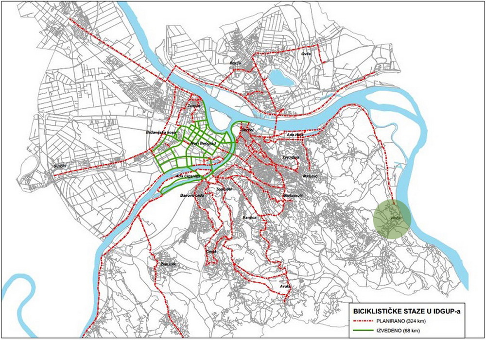
Fig. 32. Belgrade bicycle path map
6.4. Infrastructure
Current situation
In terms of infrastructure, the area covered by the competition and its direct surroundings are poorly and inadequately equipped and developed. The existing infrastructure is of uneven quality.
- Waterworks network
Within the area covered by the competition, there is partial coverage by a waterworks network and a significant number of the households have dug wells.
- Sewerage network
There is no utility sewerage network within the boundaries of the area covered by the competition.
- Electrical grid
The area covered by the competition is not adequately covered by electricity infrastructure, both in terms of the capacities and in terms of the qualitative characteristics.
- Telecommunications network
The area covered by the competition is adequately covered by telecommunications infrastructure.
- Hot water distribution system
There is no water distribution system and facilities in the area covered by the competition.
Planned situation
Bearing in mind that the current planning documentation, both for the area covered by the competition and for its surroundings, envisages development by advancing the potentials and introducing new purposes and offering new elements, which suggests fundamentally different needs from the current ones in terms of the infrastructural equipment, the development of infrastructural systems is planned in line with the development of the area.
6.5. Nature conservation and environmental protection
Nature and landscape conservation
According to the basic landscape characteristics, the area covered by the competition and its immediate surroundings belong to the landscape type of “Danube coastal zone – the sloping section of the right bank of the Danube.” This is a cultural landscape that reflects the traditional ways of using the land, in accordance with the characteristics and the limitations of the natural environment in which it is located. The favourable position between the Danube and Šumadija region’s mountains Avala and Kosmaj, has led to the development of agriculture and animal husbandry, and later of fruit growing and viticulture. The irregular, hilly terrain at 250 to 300 m above sea level is mostly dominated by small fields bordered by a rich network of hedges, with a large share of orchards and vineyards. The course of the Danube, its banks and their beauty make a landscape that provides a unique visual experience. One of the key units of this type of landscapes is Belo Brdo archaeological site. In the cross-section of cultural layers, visible from the bank of the Danube, it is possible to see the formation and development of settlements over the period of nearly 7500 years. In the context of the Danube and the hilly hinterland, the wider area of the site has a visual identity and specific landscape values, as well as all the characteristics of a historic cultural landscape.
In the zone covered by the competition, there are no protected areas for which protection procedure has been conducted or initiated, there are no ecologically significant areas of international importance belonging to the ecological network of the Republic of Serbia and there are no recorded natural properties, except for the Danube, a part of the right bank of which is within the boundaries of the area covered by the competition. With its coastal zone the Danube is an ecological corridor of national and international importance (Decree on the Ecological Network (“The Official Gazette of RS,” no. 102/10)), because it connects ecologically important areas in the Republic of Serbia, as well as the ecological networks of the neighbouring countries.
The natural vegetation on the banks of the Bolečica, as well as the Bolečica itself constitute a natural value. Individual trees and groups of trees, borderlines between plots of land and hedges that are extremely important for the migration of species and consequently for the preservation of the biodiversity also have a great importance for the nature conservation.
The area declared through the planned preservation of the existing purposes or the change of the purposes aimed at safekeeping the recognised authenticity are made possible by the keeping of: the historic context of what has been built here, the natural values of the area and the introduction of the area in the carefully thought through and appropriate economic flows.
Environmental protection
From the aspect of environmental protection, the immediate surroundings of the area covered by the competition constitute a very complex and partially degraded environment. Considering the purposes, potential air pollutants are the municipal waste landfill “Vinča” and the Institute of Nuclear Sciences “Vinča,” while possible pollutions may also originate from traffic and stationary sources.
There are no significant noise sources other than traffic.
On the territory of the municipality of Grocka, to which the settlement of Vinča belongs, there is no monitoring of the quality of environmental factors, except in the segment of surface waters, the quality of which deviates from the prescribed norms, which is also contributed to by inadequate infrastructure, especially in the field of wastewaters.
On the other hand, the subject area is characterised by favourable microclimate conditions and significant natural resources, primarily water.
The concept of environmental protection is based on the commitment to sustainable development of the city of Belgrade and consequently of the considered territory as well, which constitutes a continuous process of striking a balance between the use of the natural resources and the further development of urban functions of the city with the monitoring of the quality of air, waters and soil, currently lacking in this area, with the aim to protect and improve the environment at the level of the European standards.
6.6. Protection of the cultural heritage
In addition to the Decisions that formulate and categorise the protection of Belo Brdo archaeological site in Vinča, the SPSPA for Belo Brdo archaeological site and the conditions of the competent Institute for the Protection of Cultural Monuments, which are integrated into the Terms of Reference of this competition, the protection of the cultural heritage in the area covered by the competition has also been treated in all spatial and urban-planning documents relevant for this area as the key criterion for the planned development.
Under the Law on the Spatial Plan of the Republic of Serbia from 2010 to 2020, preserved and protected cultural heritage is a part of the vision for the spatial development of the Republic of Serbia, while “the protection, controlled and sustainable use of nature, natural resources, natural and cultural heritage” is defined as the fourth out of five basic goals of the plan. The commitment linked to cultural heritage is that “the areas with protected, developed and adequately presented cultural heritage will increase the attractiveness and competitiveness for investments and development of tourism” with the aim “to characterise cultural heritage as a developmental resource, to protect, develop and use it in a way that will contribute to the establishment of regional and local identity in conformity with the European protection standards.” Among the most important areas in that sense, the plan also includes archaeological sites from prehistory, where Vinča belongs to “the priority cultural areas that ought to enjoy special treatment, irrespective of their status within the protection service.”
The Regional Spatial Plan for the Administrative Area of the City of Belgrade recognises the diversity of cultural heritage on the territory of the city as developmental potential and it places possible directions of the development into the recreational and tourist potentials of the Danube, as well as the improvement of cultural properties and their use as the generators of economic, cultural and tourist activities. By considering the cultural heritage of “the administrative area of Belgrade and its metropolitan as one of the fundamental elements of the general development and spatial development, the basic goal of the protection, development and improvement of the cultural properties is integrative protection of cultural heritage and its management, as the generator of tourist and broader economic development. The RSPAACB treats Belo Brdo site in Vinča as a site of priority importance the development of which is based on integrative protection that constitutes a coherent system of public interventions created to stimulate and balance private and social initiatives which should learn to see cultural heritage as a non-renewable resource, a source of identification (recognition) and cultural capital that can be used for different types of renewal.
The Decree on Developing the Spatial Plan for the Special Purpose Area of the International Waterway E80 – the Danube (Pan-European Corridor VII) recognises the cultural heritage of the Danube Corridor as a potential for establishing better international cooperation and for the development of cultural tourism, while Belo Brdo archaeological site is inscribed in the list of cultural properties that is a part of the SPSPA the Danube. The general goal of the protection of immovable cultural properties is “creation of a regional identity based on the preservation, protection and tourist valorisation of the cultural heritage of the Danube region,” while the operational goals are “activation of the potentials of cultural heritage as a developmental factor, integral authenticity of cultural properties and their surroundings, protection of the properties from uncontrolled construction and good quality accessibility from the waterway, attractive presentation and interpretation, as well as the creation of conditions for better regional and international connectivity based on cultural identity.”
The Spatial Plan for a Part of the Urban Municipality of Grocka also bases the planning concept for the protection, enhancement and development of cultural heritage on the principles of integrative protection and it entails a correlation of three key elements – preservation, enhancement and use of cultural properties – as an effective mechanism that will create suppositions for durable protection of the heritage and integration into modern developmental trends in the municipality, as the only realistic path for its survival and rehabilitation. The plan sees the exceptional value and uniqueness of Belo Brdo archaeological site in Vinča as a potential for cultural and scientific connection of this area at a national and international levels, with the possibility to integrate Belo Brdo archaeological site into the cultural and tourist offer of the wider region.