The area covered by this competition is located in the settlement of Vinča, within the suburban municipality of Grocka on the territory of the city of Belgrade. Vinča is positioned on the right bank of the Danube at the confluence of the Bolečica and it is 14 km southeast of the urban part of Belgrade.
The character of the area that is the subject of the competition is established to a large degree by being a part of the Danube coastal zone. With its geographic and strategic position, the Danube connects Eastern and Western Europe. It is the only pan-European water corridor (out of ten pan-European corridors, nine are railway and road ones), the most important waterway (together with the Rhine and the Main) connecting Black Sea with North Sea and the backbone of the inner waterway network. The Danube is navigable along its entire course (588 km) through the territory of the Republic of Serbia, which belongs to the area of the middle Danube region, and has the significance of an international waterway. In the zone covered by the competition, the waterway belongs to category VII – section under deceleration downstream from Belgrade to the border with the Republic of Bulgaria. According to the Decree on the Ecological Network (“The Official Gazette of the RS,” no. 102/2010), the Danube belongs to the Ecological Network of Serbia as an ecological corridor of international importance.
5.1. History and the development of the area, architectural and cultural heritage
This hilly area represents an extraordinary geographic setting where people have been living continuously for almost 7000 years in prehistory, antiquity, the Middle Ages and very intensively since the beginning of the 19th century when the villages of Vinča, Ritopek, Grocka and Brestovik were first formed and have continued to develop in their present-day shape. On the bank of the Danube, there used to be a medieval necropolis where burials took place from the 8th to the 15th century, but no remains of a settlement from this period have been reliably detected, although the latest explorations have also shown traces of habitation in the period from the 9th to the 11th century and there are sites from the period that coincides with most of the burials (12th – 14th century). It is obvious that in the new wave of settling in the 19th century, the modern settlement annulled the position of the earlier medieval settlement.
Detailed prospecting of the terrain has been carried out on the territory of the settlement of Vinča and the neighbouring settlements, Veliko Selo in the north and Ritopek and Grocka in the south. It has been established that there are around 40 archaeological sites directed towards the Danube or in the immediate vicinity of the bank. 18 sites from the period of prehistory, antiquity and the Middle Ages have been recorded on the territory of Vinča settlement. None of these sites has been archaeologically explored. Some of the sites, such as Zukino brdo, Ravnice, Obala Bolečice, Čair and Škola, are located within the zone covered by the competition locality.
The most important cultural asset in Vinča is Belo Brdo Archaeological Site (described in detail in Part 4 of the Programme), located in the extreme northeast part of the settlement, on the very bank of the Danube, completely surrounded by pieces of land belonging to households with small residential and agricultural buildings. In this place, on the right bank of the Danube, a cultural layer around 10 m thick has been formed hiding remains of material culture from the early Neolithic (5800 BCE) to the contemporary epoch. It is an extremely important site for the exploration and study of the Neolithic period in the Balkans.
Directly next to Vinča and the archaeological site, there are three international cultural trails: the Prehistoric, the Roman and the Ottoman ones.
5.2. Broader and direct surroundings – current situation
The settlement of Vinča, which belongs to the larger suburban settlements of Belgrade, is positioned on the right bank of the Danube, bordered on the west by the regional road Belgrade-Smederevo, on the east by the Danube and on the south by the river Bolečica.
The configuration of the separated terrains of the hydrographic unit of the Bolečka River and the exit to the Danube have conditioned such position of the settlement that belongs to the group of peripheral settlements with agricultural and fruit coastal zone and that has communication orientation towards Smederevo Road and the Ring Road, with a tendency of spontaneous, expansive growth and interconnections along these roads.
The structure of Vinča settlement, concentrated in the east-west direction, along Profesora Vasića Street, that connects Smederevo Road and the bank of the Danube, and around it, consists of fragmented plots of land that are marked by family houses with curtilage. As a rule, the arable pieces of land are outside the zone of the settlement, with rare exceptions when the piece of land cultivated agriculturally is next to the curtilage within the settlement. The central elements of the settlement are grouped into two segments – around the intersection of Smederevo Road and Profesora Vasića Street – within this zone there is also the primary school Nikola Tesla with the capacity of 2000 students making it the largest in Belgrade – and in the middle zone of Profesora Vasića Street around the Church of Holy Apostles Peter and Paul built in 1857.
According to the last census (2011), Vinča has around 6,800 inhabitants, oriented towards agriculture, primarily fruit growing, and, thanks to the proximity of Belgrade’s urban zone, towards various other activities. On account of this, a significant number of inhabitants commute to Belgrade and back on a daily basis.
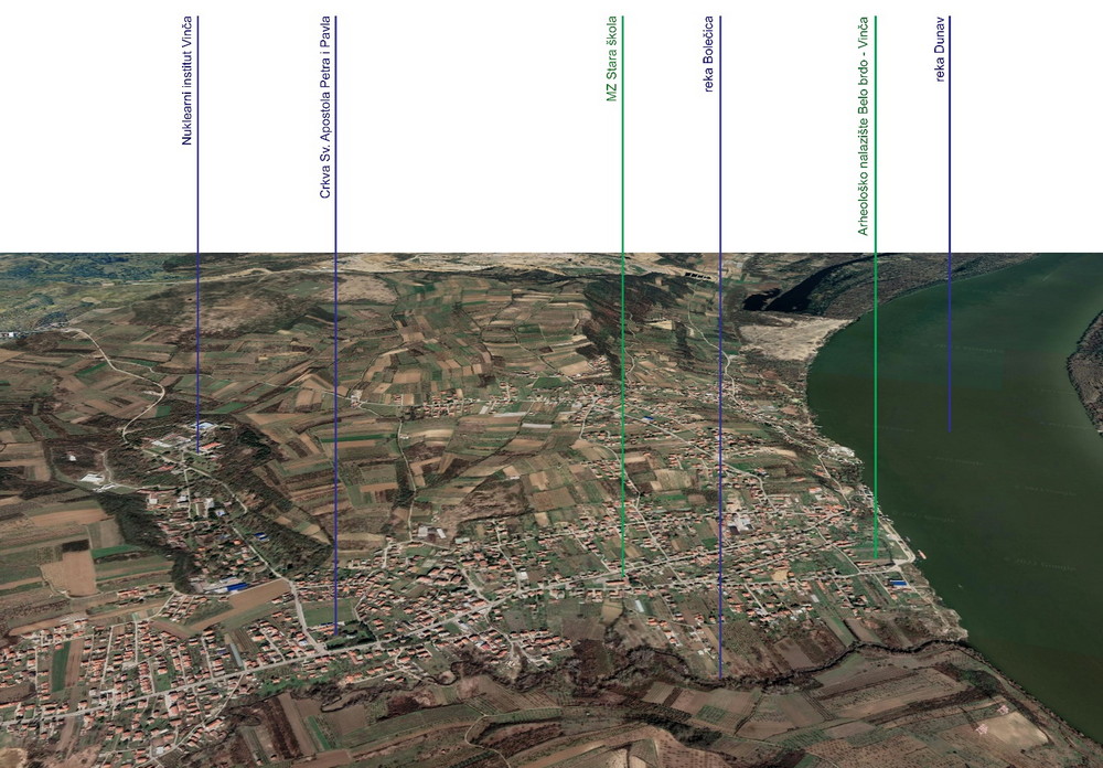
Fig. 29. MAKROCONTEXT: position of the competition area in relation to the other elements within Vinča settlement
In a broader context, Vinča is made recognisable by three important elements: the Vinča Culture archaeological site the most important locality of which is Belo Brdo, the Institute of Nuclear Sciences Vinča and one of the largest landfills in the Balkans – Vinča Landfill.
Belo Brdo archaeological site which covers an area of 11.77 hectares is located along the very bank of the Danube, some 350 m upstream from the confluence with the Bolečica River. During the 1980s, the bank of the Danube was fortified with a revetment along the length of the archaeological site.
The complex of the Institute of Nuclear Sciences Vinča, founded in 1948, is positioned near the central axis of the settlement, north of it, as an isolated whole, almost equally distant from Smederevo Road and from the Danube.
The landfill “Vinča” is located around 3.0 km from the central zone of the settlement, on the northern border of the territory of Vinča. With its position, distance and access, it is isolated from the settlement, but its current state is not in conformity with environmental standards, while a particular risk lies in occasional fires that generate additional air pollution both of the immediate and the broader surroundings, including also parts of Belgrade’s urban zone.
Downstream from the settlement of Vinča and Belo Brdo archaeological site, towards the south, a hilly landscape begins stretching along the Danube all the way to Smederevo. This is a landscape of exceptional natural characteristics, where forests and arable land – mostly covered in orchards and vineyards – intertwine dotted with holiday homes. Local river fishermen catch fish that is prepared at restaurants located on the riverbank or in higher positions with a view of the Danube and the plain of Banat region. In the centre of Grocka there is a protected spatial, cultural and historical ensemble of Gročanska čaršija, a characteristic ambience of a 19th century Serbian settlement.
5.3. Broader and direct surroundings – potentials and the planned situation
By its characteristics, the position in relation to the river and the city, as well as by the monument-based and environmental values of the settlement and its surroundings, Vinča represents a development possibility in the field of tourism, especially the cultural tourism, based on the potentials of the archaeological sites, the cultural property as an initiator of activities and recreational tourism based on the potentials of the Danube.
Apart from Belo Brdo archaeological site, there are also three international cultural trails in the direct surroundings of the place that represent an important value: the Prehistoric, the Roman and the Ottoman ones, as the most representative form of connecting and presenting cultural heritage that provides a possibility of comparative viewing at the similarities and differences within a single or between different periods, thus making it possible to learn about developmental changes and to get a clear picture of the spatial and temporal dimensions of cultural phenomena that are manifested through architecture. As of recently, systematic explorations of the cultural heritage structures and complexes, their protection and adequate purpose have created a possibility of connecting valuable complexes with a new international cultural trail that could extend along Central and Southeastern Europe. The rich layering of international cultural trails provides opportunities for interconnecting the administrative area of Belgrade and its participation in international projects the topic of which is also the planning of the economic and cultural development of large spatial segments that are mutually linked by certain common interests.
When it comes to cultural heritage as the initiator of and the basis for tourist and other economically justified activities, it is necessary to point out the importance of the so-called National Trails, the most important ones for the municipality of Grocka being the First National Trail (connecting medieval and somewhat later-dated Serbian sacral and memorial monuments: remains of monastic units in the Danube zone (Slanci, Leštane, Vinča and Rajinovac) and the Third National Trail (connecting remains of architecture which, preserved in the form of spatial units, can evoke the character of life before the great planning and urban interventions in the second half of the 20th century. These are, primarily, the čaršija (Çarşi (Bazaar)) in Grocka, Obrenovac, etc.).
For the Republic of Serbia, the Danube Belt represents an essential developmental axis and a connection with European cities and regions in the Danube basin zone as a key segment of the European space, whose economy, traffic, tourism, cultural cooperation and other forms of interconnection among the populations will be supported by plans and projects linked to Corridor VII, i.e., a joint development strategy based on international cooperation between the Danube states and the region. The Spatial Plan for the Special Purpose Area of the International Waterway E80 – the Danube (Pan-European Corridor VII) recognises the cultural heritage of the Danube Corridor as a potential for establishing better international cooperation in the development of cultural tourism. One of the planned solutions is the construction of a passenger pier in Vinča, as well as a marina in Grocka. Generally speaking, the use and the development of the river bank primarily as a public space that with its position and form connects other public spaces, constitutes its specificity. The plan envisages activation of the coastal zone and accessibility to all categories of users.
In addition to the already well-known importance of the Danube as a waterway transport route, the current planning regulations also emphasise its value as an ecological corridor of international importance belonging to the ecological network of the Republic of Serbia. There are plans for a part of the coastal belt in the zone covered by the competition in the natural and close-to-natural state to be filled and for a revetment to be built in order to prevent a negative impact of any flood wave on the archaeological site. It is planned to build a green corridor along the Bolečica, to landscape the surroundings of the site and the area of the active landslide, thus establishing an ecological network at the local level and a green infrastructure. The adequate planning of the relation between the constructed and the open spaces, and the preservation of the landscape pattern based on the use of land have ensured the preservation and improvement of the characteristic structure and the landscape.
There are plans to have a road-railway corridor through the territory surrounding the area covered by the competition as a link between the new bypass motorway from Bubanj Potok to Vinča and the road-rail bridge over the Danube. This is a very important traffic route for Belgrade, through which all economic and long-distance traffic will be directed circumferentially in relation to the city’s territory. The plans stipulate that this corridor on the left bank of the Danube will be connected with the road and street network of Pančevo and further in the direction of the Romanian border. Also, there are plans to have an exit from the motorway bypass, via “Boleč” interchange, which provides for a link between the motorway and the local road network.
The current planning documentation envisages, within the planned Boleč sewerage system, the construction of a wastewater treatment plant “Vinča” in line with the spatially most demanding concept – complete wastewater treatment, with a position on the right bank of the Bolečica in the area of the confluence of the Bolečica and the Danube.
5.4. Current planning documentation in the area covered by the competition and in the direct surroundings
The area covered by the competition belongs to CM Vinča, within the administrative area of the Municipality of Grocka and the City of Belgrade.
The current planning documentation in the area covered by the competition and in the immediate vicinity consists of the following spatial and urban plans:
- Spatial Plan for the Special Purpose Area of Belo Brdo archaeological site, “The Official Gazette of the RS,” no. 85/2018, for which the Decision on the preparation of amendments and supplements is currently being worked on
- General Regulation Plan for the construction area of the seat of a local self-government – City of Belgrade – unit XX, municipalities of Grocka, Palilula, Zvezdara and Voždovac – (settlements Kaluđerica, Leštane, Boleč, Vinča and Ritopek), “The Official Gazette of the City of Belgrade,” no. 66/17;
- Detailed Regulation Plan for the primary structures of Boleč sewerage system – PHASE 1, “The Official Gazette of the City of Belgrade,” no. 47/16;
- Spatial Plan for the Special Purpose Area of the international waterway E80 – the Danube (Pan-European Corridor VII), “The Official Gazette of the RS,” no. 14/15;
- Spatial Plan for a part of the urban municipality of Grocka, “The Official Gazette of the City of Belgrade,” no. 54/12;
- Regional Spatial Plan for the Administrative Area of the City of Belgrade, “The Official Gazette of the City of Belgrade,” no. 57/09;
The subject of the amendments and supplements to the SPSPA for Belo Brdo archaeological site primarily concerns the purposes and individual segments of the traffic solution in the area covered by the competition in order to harmonise them with the needs linked to the setting up and implementing Belo Brdo Archaeological Park complex, as well as in order to harmonise the SPSPA with the Tourist Area Study which is in the final stages of development. Also, the affirmed solutions from this competition will constitute one of the bases for the amendments and supplements to the SPSPA.
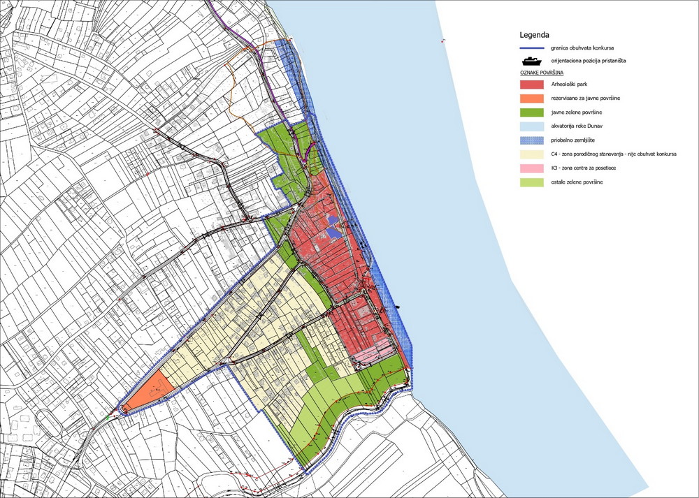
Fig. 30. Planned purpose of the land according to the SPSPA for Belo Brdo Archaeological Site for which the Decision on the preparation of amendments and supplements is currently being worked on
The SPSPA for Belo Brdo Archaeological Site has defined three zones of the site’s protection in compliance with the degree of the site’s protection:
- the archaeological site – 1st degree of protection,
- the protected surroundings of the archaeological site – 2nd degree of protection,
- the area where the existence of the site has been confirmed – 3rd degree of protection.
The coverage of the zones in accordance with the degree of protection is not the subject of the amendments and supplements of the SPSPA.
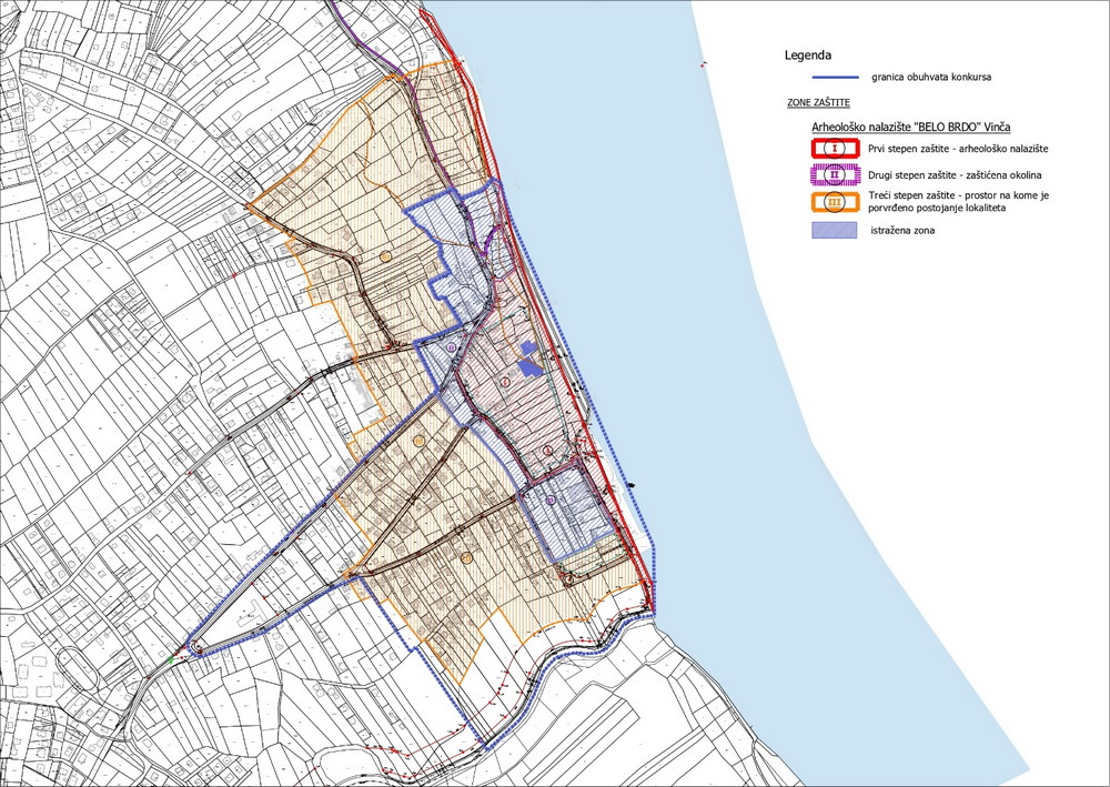
Fig. 31. Protection zones of the archaeological site according to the SPSPA for Belo Brdo Archaeological Site